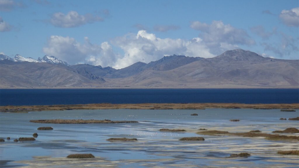
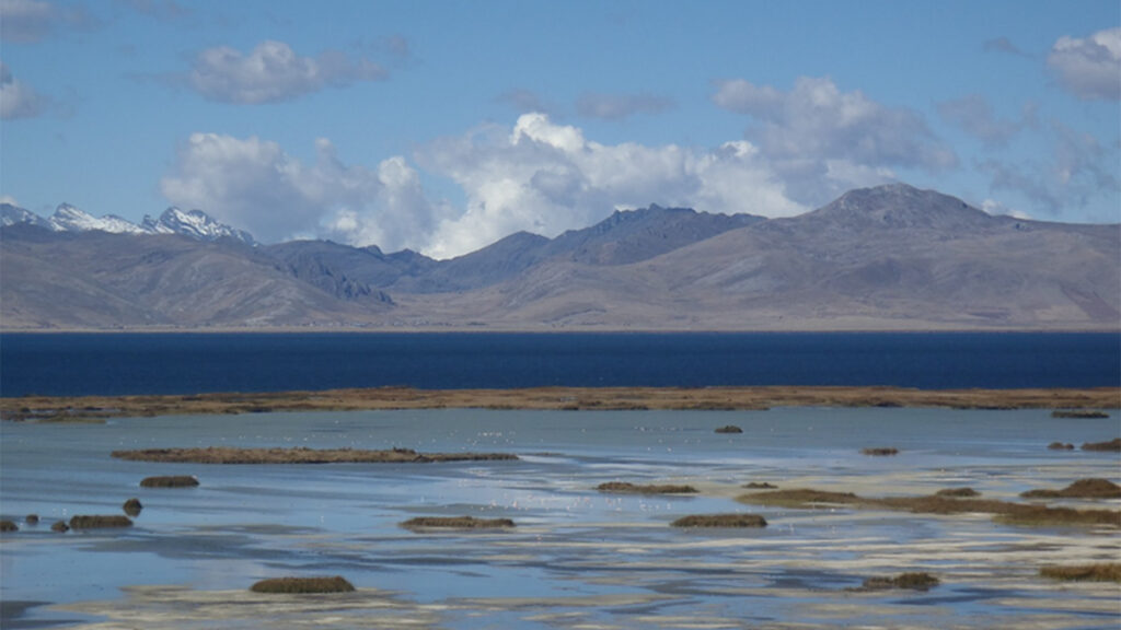
High in the central Andes, in Peru’s Junín National Reserve, park rangers, local leaders, and researchers, all participating in an initiative called Project e-Andes, huddled around a table in 2025 to discuss the reliability of flood risk forecasts for Lake Junín. One of Peru’s largest high-altitude wetlands, Lake Junín affects downstream communities, agriculture, and hydropower. Understanding flood risks at the lake is essential for protecting local livelihoods and ecosystems and for managing water resources across the wider basin.
Despite the increasing availability of satellite observations, the ability to translate environmental data from this region into reliable, decision-ready information remains fundamentally constrained. In the case of Lake Junín, rain gauges have not been deployed at sufficient density to constrain satellite-derived precipitation estimates adequately, leading to substantial uncertainty in hydrological forecasting models.
For communities depending on timely and reliable hydrological information, the consequences of such inadequate tools are not abstract.
This scene captures a core dilemma for efforts documenting hydrological processes in mountain settings, where steep and complex topography means that conditions can vary greatly across very small spatial scales. Tools and applications using remotely sensed Earth observations (EO) are becoming increasingly capable and accessible. Yet for mountain landscapes, paucities of in situ observations, such as ground-based precipitation measurements, often contribute to poorly calibrated and validated data products and unskilled biophysical models.
For communities depending on timely and reliable hydrological information, the consequences of such inadequate tools are not abstract. Rather, they directly affect resource management and disaster risk reduction decisions that affect people’s well-being. Such decisions include anticipating flood events that threaten grazing lands and infrastructure and managing snowmelt-driven water resources in the central Andes, where errors in timing and magnitude can cascade into agricultural losses and water shortages.
Beyond affecting individual decisions, sparse ground observations can limit both the local verification of EO products and the ability to characterize processes that EO and models do not adequately capture. When these limitations result in inconsistent, poorly constrained, or difficult-to-interpret information, users may lose confidence in the products and engage with them less, reducing the perceived value of investing in the observations, infrastructure, and capacity needed to improve their performance and interpretation.
This pattern constitutes a self-reinforcing data scarcity loop in which the lack of reliable ground observations undermines the perceived or real credibility, actionability, and uptake of EO and modeling products. Living labs, such as those implemented by the Peruvian-led GRADIENTES project, in which local stakeholders, researchers, and institutions collaborate to frame problems and codesign solutions in real-world contexts, offer one template for how to break these loops.
A Cycle of Data Scarcity
Earth observation data products for flood mapping or land cover monitoring, for example, are often marketed as stand-alone solutions, creating the perception that dense local networks for environmental monitoring are no longer essential. However, this framing overlooks a fundamental dependency: The performance and credibility of EO products rely on ground-based observations for calibration, validation, and interpretation. This framing thus risks sidelining ground-based monitoring, particularly in resource-constrained regions, and reinforcing undervaluations of local observational infrastructure.
Financial barriers may further limit long-term investments in the establishment, maintenance, and replacement of ground observation networks, as well as in data stewardship and training programs [Muita et al., 2021]. Insufficient investment also constrains the development of high-quality training and validation datasets, directly affecting EO products’ reliability in operational contexts. Meanwhile, data and tools perceived as unreliable lead to declining trust in EO and a reduced sense of their relevance, which discourages further engagement and, ultimately, sustains the conditions of data scarcity [Taverner, 2019].
Breaking data scarcity loops for mountain regions requires that researchers, funders, public agencies, and user organizations recognize and address distinct barriers to effective Earth observation applications.
The effects of these perceptions are felt across a variety of applications for which ground observations are not complementary but essential. For example, some EO-derived data products rely on ground observations to quantify local precipitation estimates from satellite-based passive microwave sensors [Ringerud et al., 2021]. Others require ground data to quantify ecosystem services such as rangeland productivity and hydrological regulation and carbon storage by wetlands and peatlands [Mantas and Caro, 2023] or for climate and environmental decisionmaking [Saavedra et al., 2020].
These challenges are not limited to conventional EO products. Even emerging technologies such as artificial intelligence (AI) and foundation models, despite their considerable promise, struggle to support local decisionmaking when downstream products are trained without high-quality inputs of local observations because they may fail to capture subtle but important place-specific features [Tabor et al., 2025].
Breaking data scarcity loops for mountain regions requires that researchers, funders, public agencies, and user organizations recognize and address distinct barriers to effective EO applications. Such barriers include limited uncertainty quantification of data products, model algorithms unsuited for mountain conditions, and data services that neglect FAIR (findable, accessible, interoperable, and reusable) data principles or that fail to meet user ownership, needs, and requirements [Liu et al., 2023].
Nuanced understanding is also needed to differentiate among shortcomings in products, services, expertise, and governance and to address each with tailored solutions that are scientifically robust, innovative, and locally relevant, inclusive, and actionable.
Experiences in the Andes
Cases from across the Andes show how data scarcity loops persist or break depending on several factors. These factors include the availability of and ability to maintain local data-collecting infrastructure, sustained cross-institutional coordination of and commitment to interoperable data sharing, the integration of EO into institutional workflows that translate environmental data into decisions, and the engagement of local contributors and knowledge to ensure data and decisions are relevant and responsive to local needs.
One example of how such integration can mitigate data scarcity comes from hybrid satellite–station rainfall EO products. From global to regional scales, products such as the Climate Hazards Center (CHC) Infrared Precipitation with Station data (CHIRPS) [Funk et al., 2015] depend on continuously ingesting ground-based observations to calibrate and constrain satellite estimates.
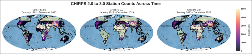
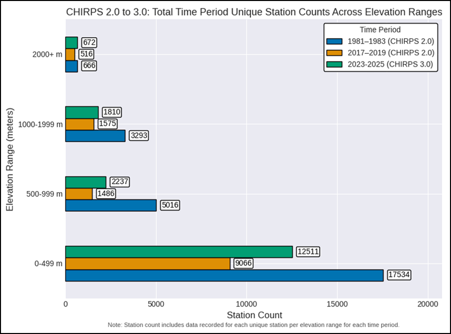
Globally, the number of precipitation monitoring stations has fallen by more than half since the early 1980s because of resource constraints and maintenance challenges (Figures 1 and 2). CHC has partially offset this decline by establishing data-sharing partnerships with more than 90 institutions worldwide [Dupar et al., 2021], such as Colombia’s Instituto de Hidrología, Meteorología y Estudios Ambientales, which supply data from 3,380 stations [Funk et al., 2015]. Strengthening in-country capacity to build, install, and maintain low-cost weather stations has also contributed to expanding station coverage and improving data accuracy [Kucera and Steinson, 2016].
In Colombia, the Infraestructura Colombiana de Datos Espaciales and the Datos Abiertos portal have laid groundwork for interoperable sharing of geospatial and environmental data among national agencies, research institutions, and regional authorities for coordinated decisionmaking. These national programs have also supported regional initiatives such as the GeoSUR platform, a decentralized system for disseminating accessible and interoperable geospatial and geographic information across South America and the Caribbean. GeoSUR operated for several years beginning in 2007, yet it ultimately demonstrated that without strong institutional coordination and sustained commitment, technical infrastructure alone was not enough to sustain the effort.
In Argentina, populations residing within the productive agricultural areas of the country’s central Andes rely on high-elevation snowmelt as the primary source of water. The national runoff forecast system issued by the Secretariat for Infrastructure and Water Policy estimates the timing and volume of snowmelt annually for the region. However, it does not currently incorporate advanced models or remotely sensed EO data, despite the availability of such models (including AI) and accurate estimates of changes in snow-water equivalent from satellite interferometric synthetic aperture radar data.
Rather, the national system relies on coarse-scale climate models and limited and spatially heterogeneous ground-based measurements (e.g., soil moisture), meaning its forecasts are less reliable and useful than they could be for effective local decisionmaking. The disconnect is emblematic of the difficulty of embedding new EO capabilities into institutional workflows shaped by legacy practices.
In Peru, land cover maps of Junín National Reserve had previously proved of little use to local planners for resource management and other value-adding initiatives because they failed to capture ecologically distinct vegetation types and hydrological processes. To address this challenge, the locally led Project e-Andes recently blended AI-driven analysis of multisensor satellite imagery with in situ data and local knowledge to produce consensus land cover maps and lake water level records and forecasts for the reserve.
Through a process of codesign with researchers, local leaders identified user-appropriate land cover classes for future maps (i.e., local vegetation types) and modeling priorities such as water balance dynamics, water level fluctuations, and vegetation conditions linked to pastoral systems and ecosystem health. Their efforts in this living lab environment highlight the importance of integrating ground observations, context-sensitive satellite EO, and modeling with local priorities, workflows, and capacities while demonstrating a scalable template for other catchments.
From Scarcity to Stewardship
A central cause of persistent data scarcity is the discontinuity between the short-term operational and funding cycles of individual research projects and the long-term requirements of sustained environmental monitoring.
A central cause of persistent data scarcity is the discontinuity between the short-term operational and funding cycles of individual research projects (which are often led from afar) and the long-term requirements of sustained environmental monitoring. In too many cases, essential infrastructure such as rain gauges and soil sensors are deployed during pilot initiatives, only to fall into disrepair once a project’s funding ends and no clear maintenance plan exists.
The concept of place-based living labs can address this disconnect by embedding the responsibility for maintaining monitoring infrastructure within the operational scope of local organizations. When this infrastructure is locally managed, its relevance is continuously reinforced through direct use of the information gathered for decisionmaking, and its upkeep becomes a shared priority among stakeholders rather than an external dependency. Furthermore, when local data are made openly available, they can serve as a foundation for generating value-added products downstream, such as localized flood forecasts and pasture conditions, and for supporting the development of local digital economies.
By enabling localized ownership of both data infrastructure and knowledge generation, living labs offer a means to solve technical challenges. They also embody a viable governance framework for sustaining ground-based environmental monitoring. In doing so, they can contribute to overcoming persistent barriers to EO adoption and to reducing data scarcity.
Living labs may be particularly valuable where sparse ground observations limit local verification of EO products but where EO can, nevertheless, provide information that would otherwise be unavailable. By making the implications of these uncertainties explicit for specific decisions while identifying where additional observations would most improve confidence and utility, living labs can enable responsible use of available EO as observational capabilities and local capacity are strengthened. Mountainous areas, like the Peruvian Andes, provide a particularly suitable test bed for this approach.
Living labs established by an international, but locally led, consortium are integrating satellite observations with in situ measurements and local knowledge to codevelop and sustain decision support tools.
GRADIENTES, a project across four such high-altitude pilot regions in the Peruvian Andes (Junín, Jauja, Tarma, and Huancavelica), offers a promising example of a collaborative living lab approach with the potential to fill gaps not only in technical capacity but also in institutional commitment and local relevance of the information produced.
In these watersheds, living labs established by an international, but locally led (Universidad Nacional Agraria La Molina), consortium are integrating satellite observations with in situ measurements and local knowledge to codevelop and sustain decision support tools for water management, ecosystem monitoring, and climate adaptation. By building on the experience of Project e-Andes in Junín, GRADIENTES may lay groundwork for this approach to expand across the region.
The Road Forward
Breaking data scarcity loops in mountainous regions is essential for meeting local climate, water, and land management challenges. The way forward is clear: Researchers, funders, and public agencies must invest in long-term environmental monitoring infrastructure that is under local governance and is integrated with EO data so that local and global observations inform each other. They must also support institutional continuity to maintain this infrastructure and prioritize participatory approaches that combine scientific expertise and community knowledge and needs.
The experiences and promise of living labs in the Andes show that when EO tools are adequately informed by on-the-ground data and are codeveloped and used within local institutions, they foster a sense of ownership, build trust, and improve the relevance of the data they produce and the decisions they support. This approach is an effective strategy for promoting uptake and application of EO and a blueprint for more resilient, inclusive, and adaptive environmental governance.
Acknowledgments
We thank Chris Funk, Laura Harrison, Greg Husak, and Pete Peterson from the Climate Hazards Center for providing the CHIRPS station data. We also thank Liliana Castillo for her insights and contribution to the discussions. This work was funded by the Foundation for Science and Technology, Instituto Público of the Ministério da Ciência, Tecnologia e Ensino Superior (Portugal), through national funds (Programa de Investimentos e Despesas de Desenvolvimento da Administração Central) LA/P/0068/2020 and UID/50019/2025, and by the European Union’s NextGenerationEU under projects UID/PRR/50019/2025 and UID/PRR2/50019/2025. The GRADIENTES Project, “Vegetation Dynamics as a Response to Precipitation Changes along an Altitudinal Gradient of Land Use in the Peruvian Andes,” is supported by contract PE501088034-2024-PROCIENCIA. Additional support was provided by the partnership of the NASA Minority University Research and Education Project (MUREP) and The National GEM Consortium.
References
Dupar, M., L. Weingärtner, and S. Opitz-Stapleton (2021), Investing for sustainable climate services: Insights from African experience, 56 pp., Overseas Dev. Inst., London, https://www.econstor.eu/handle/10419/251137.
Funk, C., et al. (2015), The climate hazards infrared precipitation with stations—A new environmental record for monitoring extremes, Sci. Data, 2(1), 150066, https://doi.org/10.1038/sdata.2015.66.
Kucera, P. A., and M. Steinson (2016), Low cost weather instrumentation, Meteorol. Technol. Int., 14–20.
Liu, Z., et al. (2023), We need a better way to share Earth observations, Eos, 104, https://doi.org/10.1029/2023EO230190.
Mantas, V., and C. Caro (2023), User-relevant land cover products for informed decision-making in the complex terrain of the Peruvian Andes, Remote Sens., 15(13), 3303, https://doi.org/10.3390/rs15133303.
Muita, R., et al. (2021), Towards increasing data availability for meteorological services: Inter-comparison of meteorological data from a synoptic weather station and two automatic weather stations in Kenya, Am. J. Clim. Change, 10(3), 300–316, https://doi.org/10.4236/ajcc.2021.103014.
Ringerud, S., et al. (2021), Applications of dynamic land surface information for passive microwave precipitation retrieval, J. Atmos. Oceanic Technol., 38, 167–180, https://doi.org/10.1175/JTECH-D-20-0048.1.
Saavedra, M., et al. (2020), Impacts of topography and land use changes on the air surface temperature and precipitation over the central Peruvian Andes, Atmos. Res., 234, 104711, https://doi.org/10.1016/j.atmosres.2019.104711.
Tabor, K. M., N. Stavros, and M. B. Holland (2025), Local conservation action requires ethical investments in global digital equity, Environ. Conserv., 52(1), 9–19, https://doi.org/10.1017/S0376892924000274.
Taverner, D. (2019), Evaluation of Earth observation for sustainable development, 75 pp., Caribou Space, Farnham, U.K., https://caribou.global/publications/evaluation-of-earth-observation-for-sustainable-development/.
Author Information
Vasco Mantas (vasco.mantas@dct.uc.pt), Instituto Dom Luiz and Centre for Earth and Space Research of the University of Coimbra, Department of Earth Sciences, Universidade de Coimbra, Coimbra, Portugal; Karyn Tabor, Science Systems and Applications Inc., Lanham, Md.; also at NASA Goddard Space Flight Center, Greenbelt, Md.; Claudia Caro, Universidad Nacional Agraria La Molina, Lima, Peru; Marcelo Uriburu Quirno, Comisión Nacional de Actividades Espaciáles, Buenos Aires, Argentina; and Cassidy Ochoa, NASA Goddard Space Flight Center, Greenbelt, Md.; also at Department of Atmospheric and Environmental Sciences, University at Albany, Albany, N.Y.
Citation: Mantas, V., K. Tabor, C. Caro, M. Uriburu Quirno, and C. Ochoa (2026), Breaking data scarcity loops in mountainous regions, Eos, 107, https://doi.org/10.1029/2026EO260331. Published on 22 October 2026.
This article does not represent the opinion of AGU, Eos, or any of its affiliates. It is solely the opinion of the author(s).
Text © 2026. The authors. CC BY-NC-ND 3.0
Except where otherwise noted, images are subject to copyright. Any reuse without express permission from the copyright owner is prohibited.