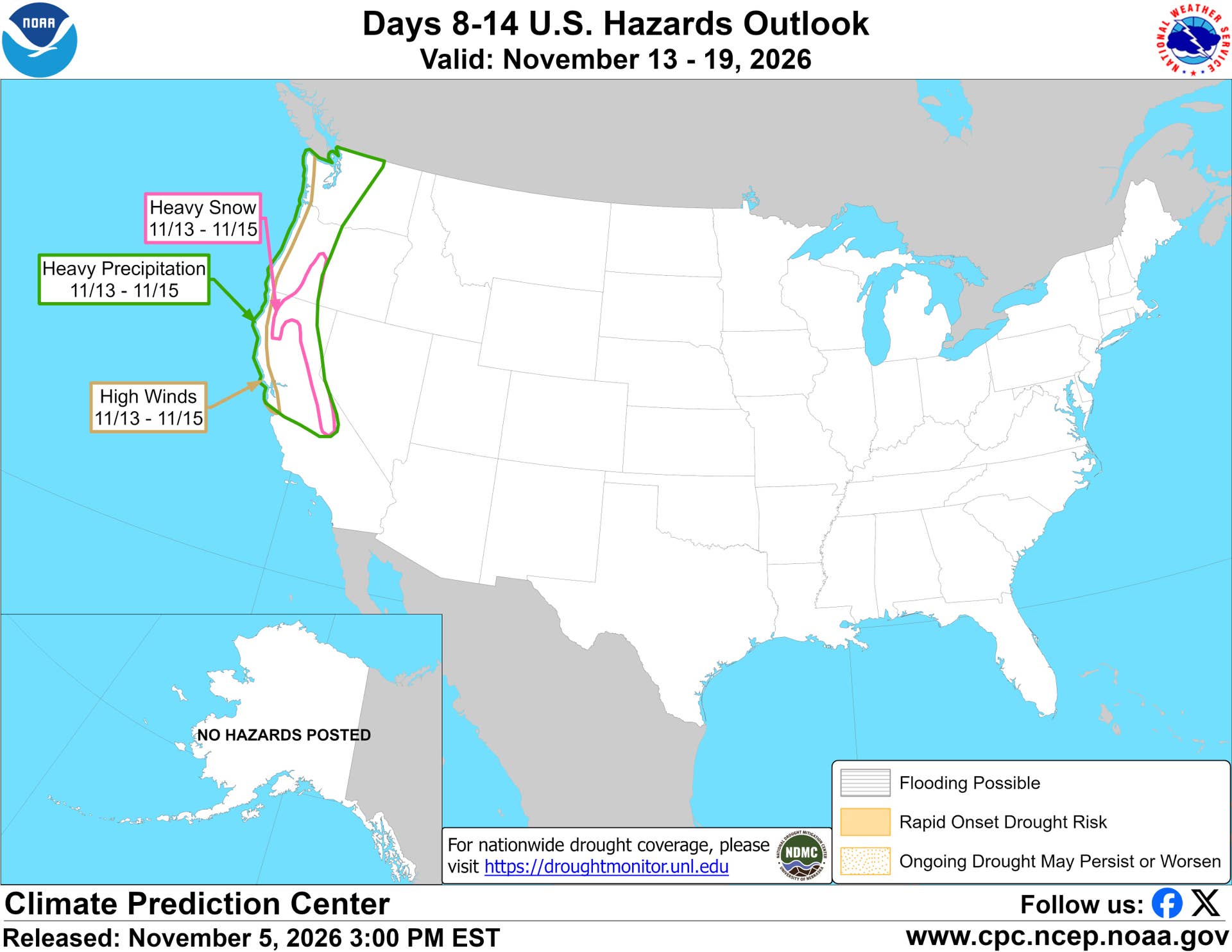
Two West Coast states face a moderate risk of heavy snow from Friday, Nov. 13, through Sunday, Nov. 15, according to the Climate Prediction Center’s week two hazards outlook, made Nov. 5 and covering Nov. 13 to 19. The risk overlaps several major mountain routes, where drivers could face chain controls even if conditions stay wet at lower elevations.
Where The Heavy Snow Risk Sits
The heavy snow zone on the map covers two states, running from southern Oregon down the length of the Sierra Nevada in California:
- California: the Sierra Nevada and the Klamath Mountains
- Oregon: the mountains of southern Oregon, including the Klamath range
Heavy precipitation extends beyond the snow zone on the snow map, reaching Washington as well as Oregon and California. With snow levels expected to stay high, most of it should fall as rain at lower elevations. The coasts of all three states also carry a moderate risk of high winds Nov. 13 to 15.
NOAA / Climate Prediction Center
Beyond the map’s main zone, the outlook text adds a slight risk of heavy high elevation snow through Nov. 17 for the Cascades, parts of the northern Intermountain West and Great Basin, and the Central and Northern Rockies.
The chances of three-day snow totals topping 6 inches have also declined since the Nov. 4 outlook, according to CPC forecaster Thomas Collow. A slight wind risk covers much of the West Coast and Interior West through Nov. 17.
A Late First Freeze Farther East
Most of the Lower 48 leans warm on the map. The exception is overnight lows in parts of the Middle Mississippi Valley, Ohio Valley and Mid-Atlantic, where the CPC says near freezing nights would mark the first freeze for many areas, two to three weeks later than usual.
The Polar Vortex Wild Card
The longer-range outlook is complicated by the possibility of an unusually early disruption of the polar vortex. In its updated November outlook, the CPC calls a November sudden stratospheric warming very rare and says its effects can show up for up to two months. Forecast guidance points to a possible brief reversal of the stratospheric winds in the second week of November, which would come more than two weeks earlier than any November event in NOAA’s compendium of sudden stratospheric warmings, The Watchers reports. Surface effects usually lag by weeks, which puts late November and December in the window to watch.
What It Means For Drivers
The heavy snow zone covers Interstate 80 over Donner Summit and U.S. 50 over Echo Summit. Drivers on those routes Nov. 13 to 15 should expect chain controls near the top, even if the lower part of the drive is only wet.
California uses three levels of chain controls. At R2, the most common level in the Sierra, four wheel and all wheel drive vehicles with snow tires on all four wheels can skip chains but still have to carry them. At R3, every vehicle needs chains.
High winds along the coast make driving harder for SUVs, pickups, vans and anyone towing a trailer. Slow down on open stretches and bridges.
Final Thoughts
The snow risk is limited to high elevations and could be lowered in the next update. If you plan to cross the Sierra or southern Oregon that weekend, pack chains, fill the tank and check Caltrans QuickMap or ODOT TripCheck before you leave. Drivers farther east should also watch for the season’s first freezing nights. Check tire pressure in the morning, since it drops about 1 psi for every 10-degree Fahrenheit drop in temperature.