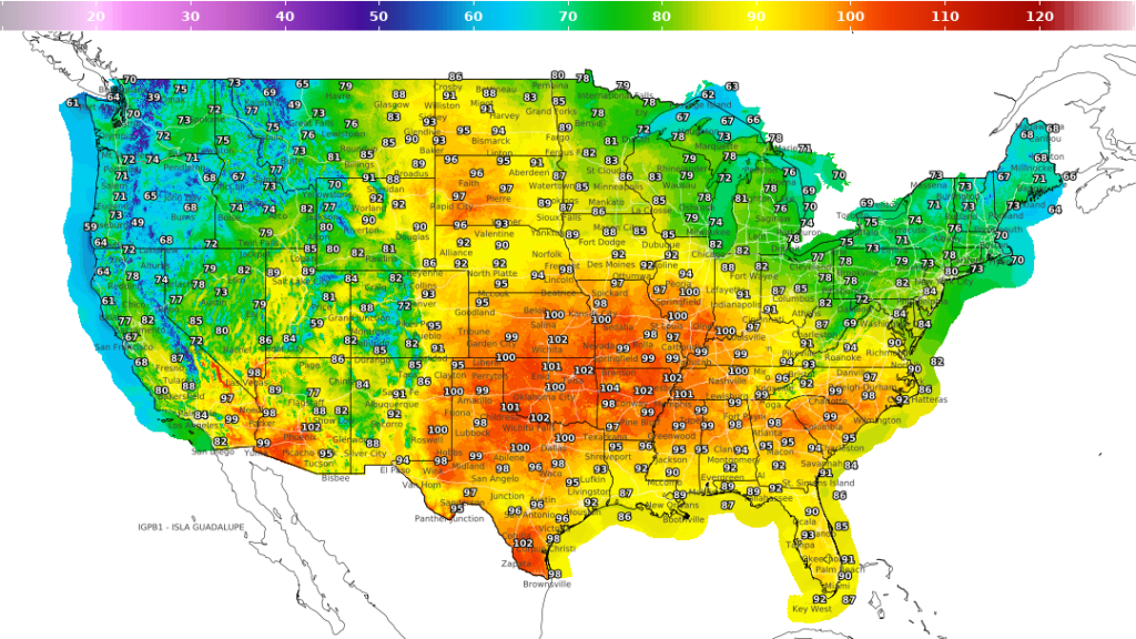
The National Weather Service’s national digital forecast splits the country almost exactly in half for the holiday weekend. Everything from the Rockies west is running cool and wet. Everything from the Plains to the Mississippi Valley is running dangerously hot. If you are driving anywhere over the next three days, you are probably crossing that line.
Peak danger window: Sunday afternoon through Monday evening, when Major to Extreme HeatRisk covers the central and southern Plains and a strengthening low fires severe storms across the northern Plains and Upper Midwest.
The Middle of the Country Is Baking
The heat is the headline. Kansas, Oklahoma, Missouri, Arkansas and Texas are forecast into the upper 90s and low 100s, with 104 showing near the Kansas and Missouri line and 102 across the southern Plains. Overnight lows only fall into the mid 70s, which is what turns a hot weekend into a health problem. Heat advisories and an excessive heat warning stretch from the mid Mississippi Valley into the Ohio and Tennessee valleys and out to parts of the Mid-Atlantic coast. Forecasters expect this to hold through Labor Day and into next week.
The West Is 15 Degrees Below Normal
A slow-moving upper low parked over the Pacific Northwest has the entire West Coast running cool. Highs in the 60s and low 70s cover Washington, Oregon, Idaho and western Montana, with 61 on the northern Washington coast. Expect a half inch to two inches of rain across the Northwest and northern Rockies through Monday. Snow levels in the Cascades drop toward 7,000 feet, which is high enough to leave every pass clear.
Monsoon Moisture Targets Arizona and New Mexico
Southwest monsoon storms continue all weekend, with a Slight Risk of excessive rainfall over Arizona and New Mexico. Flash flooding is most likely over burn scars and dry washes. Hurricane Marie is tracking west and out to sea, but a glancing plume of its moisture may reach Southern California, northern Arizona and Utah Sunday into Monday. Model agreement on how much rain that produces is poor.
Storms Build Across the Northern Plains
A low pressure system moves northeast across the northern Rockies and northern Plains late Sunday into Monday, bringing widespread showers, locally heavy rain and a growing severe weather threat across the Dakotas, Minnesota and Wisconsin. Along the Gulf Coast and Florida, scattered storms continue along a sagging frontal boundary.
What This Means Behind the Wheel
Triple-digit pavement is hard on underinflated tires and on any cooling system already running marginal, and Labor Day is the year’s second-heaviest travel period. Check tire pressure cold, before you drive, since heat inflates the reading. In the Southwest, treat a flooded wash as a closed road no matter how shallow it looks. In the northern Plains Monday, expect standing water and sudden visibility drops in heavy rain.