The Storm System Shifts East
The severe weather system that battered the Central Plains on Friday is now pushing eastward, bringing a fresh wave of hazards for Saturday morning commuters and weekend travelers. As the cold front sweeps across the country, the primary threat zone for intense thunderstorms is moving directly into the Ohio and Tennessee Valleys, extending down into the Deep South. This system is packing a significant amount of moisture and energy, setting the stage for a highly disruptive and potentially dangerous weekend on the roads.
Severe Crosswinds and Hail Hazards
For drivers on interstate highways and local routes through eastern Kentucky, West Virginia, and Pennsylvania, the immediate threats include sudden, violent weather shifts. Forecasts indicate a high likelihood of sudden downpours that will instantly reduce visibility to zero. Accompanying these torrential rains are damaging straight-line winds that can easily destabilize high-profile vehicles. Furthermore, large hail remains a significant risk within these storm cells, posing a direct threat to windshields and making highway speeds exceptionally perilous.

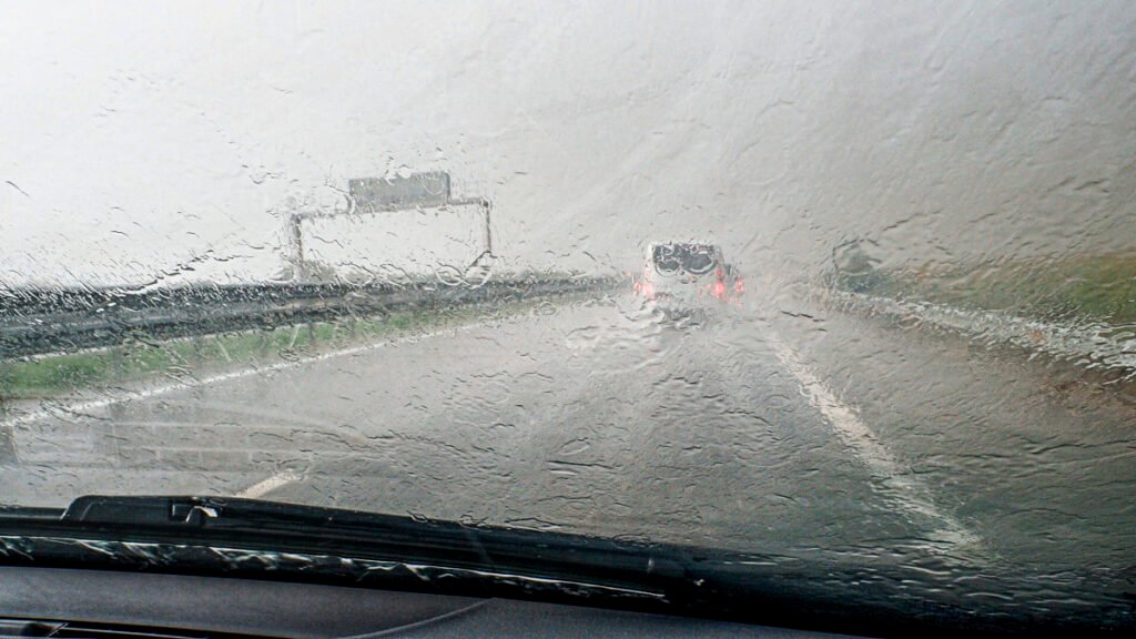
Flash Flooding and Hydroplaning Risks
The most widespread and life-threatening hazard for motorists this weekend is the potential for flash flooding. The storm system is expected to produce training thunderstorms, where repeated heavy downpours track over the exact same locations. Areas stretching from Dallas and Fort Worth all the way up through Nashville are bracing for up to four inches of rapid rainfall. This volume of water will quickly overwhelm drainage systems, leading to deep pooling on major highways and a severe risk of high-speed hydroplaning.
Driving Safety and Route Planning
Navigating through these conditions requires extreme caution. Drivers must drastically reduce their speeds to prevent hydroplaning and increase following distances to account for slick, waterlogged brakes. The most critical rule of storm driving remains unchanged: never attempt to drive through flooded roadways. It only takes a few inches of moving water to sweep a vehicle away or stall an engine. If you are traveling through the Ohio or Tennessee Valleys this Saturday, actively monitor local weather alerts and be prepared to pull over safely if visibility drops or water begins to cover the road.

Pre-Trip Vehicle Checks for Wet Weather
Before turning the key this weekend, take five minutes to inspect your vehicle’s rain readiness. Visibility and traction are your only lifelines in a severe deluge. Check your wiper blades for any tearing or streaking, and ensure your washer fluid reservoir is completely topped off to clear away muddy road spray. Most importantly, verify your tire tread depth. Tires nearing the end of their life will drastically increase your risk of hydroplaning at highway speeds. Finally, make it a habit to manually turn on your headlights in heavy rain, as automatic settings often fail to activate during daytime storms, leaving you nearly invisible to the drivers behind you.