
On 16 September 2023, a low hum started swaying seismometers around the world. Unlike during the short and jagged frenzy of an earthquake, this signal wobbled every 92 seconds and continued for 9 days. About a month later, while seismologists were still puzzling over the incident, the hum started again and lasted roughly a week.
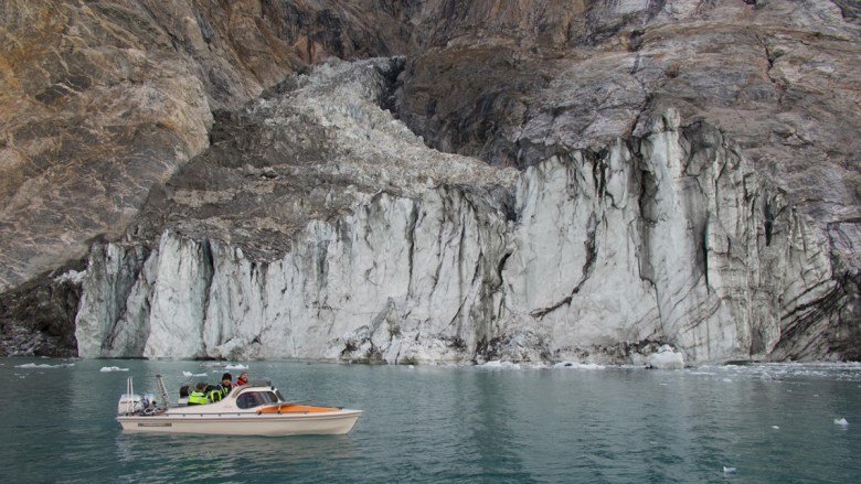
Researchers traced the confusing signals to East Greenland, where satellite imagery revealed the scars of recent rockslides in Dickson Fjord. They deduced that millions of cubic meters of rock and ice had suddenly fallen into the sea on 16 September, creating a 200-meter (650-foot) tsunami and a long-lasting wave called a seiche. Rather than ricochet out to sea, crooked topography kept the tsunami sloshing back and forth between the fjord’s parallel walls. The later hum was from a second, smaller rockslide and seiche.
The area is unpopulated, meaning no one was threatened by the initial wave but no one observed the event either.
Seiches typically need a continuous energy source such as a windstorm to persist, but the long-lasting waves in Dickson Fjord appeared to be self-sustaining. Two teams independently developed simulations showing Dickson Fjord could support a long-lasting seiche. A new study in Nature Communications builds on that work, using satellite data to provide the first direct observations of the seiche.
“To really robustly be able to say, ‘This is what was shaking the Earth at this time,’ we needed that observational evidence,” said Thomas Monahan, an oceanographer at the University of Oxford and first author of the new paper.


As Above, So Below
East Greenland is remote, and the seiche mostly dissipated before the Danish military arrived 3 days after the initial wave to investigate the collapsed mountain face in Dickson Fjord. By then, the amplitude of the wave was already too small to detect from the boat. However, the shift in sea surface was visible from space thanks to the international Surface Water and Ocean Topography (SWOT) satellite, launched in 2022.
“We’ve never had the capability to do things in these regions at this level before.”
SWOT uses two altimeters spaced 10 meters apart to triangulate small changes in water height. Prior to SWOT, satellites had one altimeter and could offer a one-dimensional footprint of the ocean. Now, Monahan said, researchers can obtain precise, high-resolution imagery of the sea surface, even between the deep walls of a distant fjord.
“We’ve never had the capability to do things in these regions at this level before,” he said.
The satellite passed over Dickson Fjord several times during the main event and the smaller rockslide that followed. Monahan and his colleagues examined SWOT data from four transits, tracking the sea surface slope along the same transect each time.
The water was sloshing back and forth between the fjord walls.
The researchers extended their search to rule out other causes. The timing of the waves did not match the timing of winds recorded by a weather station in the fjord or the pattern of tides recorded by SWOT over the next 13 months. The magnitude of the wave did, however, match the seismic signal, further suggesting the fjord’s geometry had trapped a wave.

“Science at Its Best”
The study further confirmed the seiche but also showed the early utility of SWOT, which had finished calibrating just 2 months before the initial rockslide.
“They’re sort of perfect partners, satellite and seismic data.”
“It’s a nice surprise to see the result,” said Yao Yu, a physical oceanographer who works with SWOT data at the Scripps Institution of Oceanography. The satellite is built for oceans, rivers, and lakes, she said, but the new study shows it can also collect good data from high-latitude fjords in areas unreachable by prior satellites. “A lot of things we never expected SWOT can do, it’s actually working very well,” she said.
SWOT’s spatial resolution is especially important in the Arctic, where seismometers are sparse. The satellite provides only intermittent observations, but it can access remote locations. That fills a gap, said Stephen Hicks, a seismologist at University College London and coauthor on one of the original seiche papers.
“They’re sort of perfect partners, satellite and seismic data,” he said. The new study backs up and builds upon the original research, he added, and “that’s sort of science at its best.”
—J. Besl (@J_Besl), Science Writer
Citation: Besl, J. (2025), New satellite adds evidence of an Earth-shaking wave, Eos, 106, https://doi.org/10.1029/2025EO250236. Published on 1 July 2025.
Text © 2025. The authors. CC BY-NC-ND 3.0
Except where otherwise noted, images are subject to copyright. Any reuse without express permission from the copyright owner is prohibited.