Managing fires in tropical forests can be a daunting task: Loggers and arsonists often move faster than first responders, resources are scarce, and the territory is immense. In the Brazilian Amazon, these obstacles strain a chronically underfunded environmental sector whose field agents face threats from farmers and, increasingly, organized crime.
In 2024, fires consumed 30.8 million hectares across Brazil—79% more than in 2023. More than 80% of the total burned area was inside the Legal Amazon, according to the environmental data platform MapBiomas. (The Legal Amazon is a government-designated region consisting of all nine of Brazil’s states in the Amazon basin.) Because of the scale of the fires, in August 2024, the Brazilian Institute of Environment and Renewable Natural Resources (IBAMA) increased its fire patrols to 2,227 brigadiers (firefighters), with 1,239 of them—more than half—stationed in the Legal Amazon.
Millions of Hectares in Acre
Acre is Brazil’s westernmost state, borders Peru and Bolivia, and is part of the Legal Amazon. In Acre, four professional fire brigades with 68 full-time firefighters operate in three municipalities and one protected area. A volunteer brigade also works near the state’s capital and largest city, Rio Branco.
With about 14 million hectares of forest to patrol, these forces can cover only a fraction of Acre’s territory.
Science, it turns out, has been an important tool to close that gap, because the challenge of firefighting in Acre is not just a shortage of squads on the ground; it’s also related to data access. Brazil’s environmental information is scattered across myriad agencies: the National Institute for Space Research (INPE), federal environmental agencies like IBAMA and the Chico Mendes Institute for Biodiversity Conservation, the National Water Agency (ANA), and Brazil’s National Center for Monitoring and Alerts for Natural Disasters, as well as individual state secretariats, each working with its own priorities and cadences.
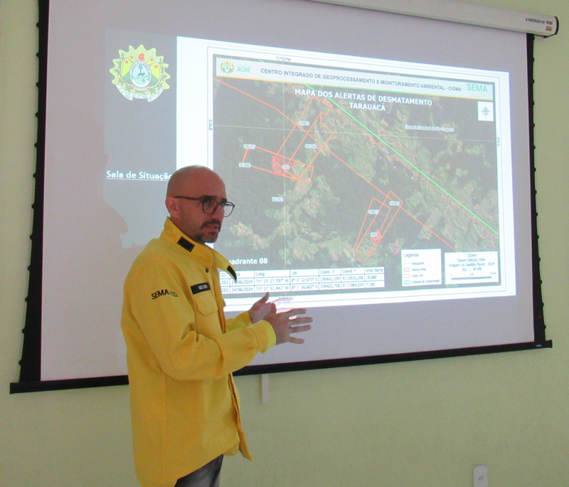
Without data in compatible formats, crucial information can overlap or contradict. “To know where to act, we need qualified information—land tenure, zoning, fire hot spots. Without that, any public policy for fires or deforestation will be ineffective in the Amazon,” said Claudio Cavalcante, chief at the Center for Environmental Geoprocessing (CIGMA), the geospatial hub Acre created within its Environmental Secretariat in 2020 to connect deforestation and fire monitoring with policy response.
CIGMA has made efforts to integrate data from across Brazil’s federal and state agencies to inform agents on the ground. “We have worked with data stratification: deforestation [in areas] from 1 to 5 hectares, then areas from 5 to 10 hectares, and then from 10 to 50. Automating some data fluxes has been a really complex and labor-intensive process,” added Cavalcante, who took part in a meeting with researchers, communicators, and policy experts at CIGMA’s headquarters in July.
Eyes on the Data
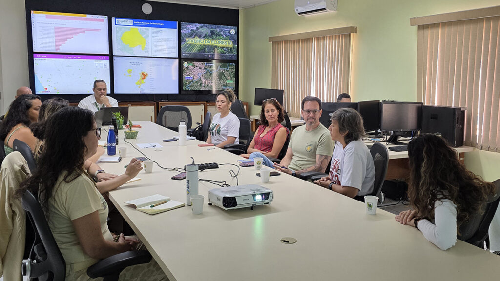
All that integration takes place in CIGMA’s Situation Room, where scientists and analysts assess live feeds of fire alerts, air quality, river levels, rainfall, drought indices, and a host of other data.
“All the maps for action on the ground are developed here. We also prepare the monthly deforestation reports and technical notes,” said Quelyson Souza, who coordinates Acre’s Environmental Secretariat’s Environmental Command and Control Group.
CIGMA’s system merges INPE fire alerts with land tenure and zoning data to identify potential violators. Hydrological data from ANA, the water agency, updates every 15 minutes and feeds data to the state’s Civil Defense and Fire Department. Air quality sensors detect smoke coming from forests within or beyond Brazil’s borders.
To the coordinator of Environmental Protection Operations of Acre’s Firefighting Corps, Major Freitas Filho, the scientific data his corps has access to on the ground “is essential to optimize and refine the use of operational resources.” Acre’s fire department leads the Controlled Fire Operation, which focuses on integrating teams of military and environmental agents to fight fires during the dry season, which spans the second half of the year.
According to a report on fire management in the Amazon forest released earlier this month by the Amazon Environmental Research Institute (IPAM Amazônia), Acre has a very effective model of linking data and governance that recommends early-warning systems and open data sharing so municipalities and communities can act quickly.
Lessons from Acre
Despite the challenges, Acre stands out as one of the few Amazonian states where scientists, firefighters, and policymakers share the same room.
“It’s inspiring to see the evolution of Acre’s Situation Room. I’ve used it as a national example because action happens on the ground, even across borders,” said Liana Anderson, a remote sensing researcher at INPE.
“It’s much harder to be fooled by offenders who try to get away with their environmental wrongdoing. It’s like lifting the blindfold over one eye when you’re playing blindman’s buff.”
As Brazil prepares to host COP30 (the 2025 United Nations Climate Change Conference) in Belém, scientists and policymakers hope Acre’s experience can be an example of science-focused environmental management: Unified datasets, shared dashboards, and collaboration can turn information into planning and action.
“When we get to a cleared area with the information we now have access to, it’s much harder to be fooled by offenders who try to get away with their environmental wrongdoing,” Souza said. “It’s like lifting the blindfold over one eye when you’re playing blindman’s buff.”
—Meghie Rodrigues (@meghier.bsky.social), Science Writer
Meghie Rodrigues visited CIGMA’s headquarters in Acre as part of a press trip organized by IPAM Amazônia.
Citation: Rodrigues, M. (2025), In parts of the Brazilian Amazon, science leads the fight against forest fire, Eos, 106, https://doi.org/10.1029/2025EO250406. Published on 30 October 2025.
Text © 2025. The authors. CC BY-NC-ND 3.0
Except where otherwise noted, images are subject to copyright. Any reuse without express permission from the copyright owner is prohibited.