Derek Cronmiller of the Yukon Geological Survey has provided a stunning set of the images of the fascinating recent failure that partially blocked the Yukon River.

Following my post yesterday about the May 2025 landslide on the Yukon River, Derek Cronmiller, who is head of Surficial Geology at the Yukon Geological Survey kindly made contact to provide further information about this most interesting failure. He has also provided an amazing set of images of the landslide.
Derek noted the following about the landslide:-
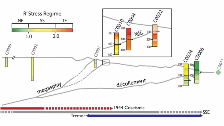
“The slide is a 9 km above Lake Laberge and happed sometime between May 14th and 18th as constrained by Sentinel imagery and river user reports.“
“The slide is 950 m wide and up to 250m long from crown to toe. It blocked ~ 45% of the active channel which is no small feat on the Yukon River! The material is finely bedded glaciolacustrine silt and clay at river level (and below) grading up to massive medium to coarse sand at the top of the main scarp with variable thickness of aeolian dune cover at the surface. Perhaps the most interesting part of the slide is that the rupture surface daylighted somewhere in the river and thrust river bottom sediments (and vegetation) several metres above the river level. There are some great spreading structures on the slide reminiscent of sensitive clay slides in Quebec. We observed seeps daylighting at the bottom of the adjacent slopes just above river level at the transition from sands to silt and clay. Slides have occurred here in the past but an order of magnitude smaller.”
And so to the images. This image shows the landslide from a drone, looking from the crown towards the river:-

The very beautiful morphology of this landslide is visible with rows of back-tilted trees, with upright trees in between. Note also the uplifted toe of the landslide, including river gravels.
Let’s take a look at the toe – here is the uplifted portion, located almost half way across the former channel. The scale of the uplift here is really impressive:-

For those who are unfamilar with rational landslides, and who may be wondering how this is possible, I provided a sketch of this mechanism back in 2013 at the time of the Hatfield Stainforth landslide:-

This rotational generates some complex structures in the landslide, including horst and graben phenomenon:-

And this image shows the uplifted river gravels in more detail:-

Moving up into the main body of the landslide, there are some extremely impressive back-tilted blocks:-

And also some horst and graben structures:-

Finally, there are areas of seepage as Derek noted above, which probably gives an indication of one of the drivers of this landslide:-

This is a really interesting landslide – in many ways, a textbook example of a complex rotational failure. If I was still teaching, I would use this landslide to illustrate the mechanisms of rotational landslides.
Many thanks to Derek Cronmiller and his colleagues at the Yukon Geological Survey for providing these amazing images and the detailed commentary. I hope that they will write the landslide up for publication in due course.
Text © 2023. The authors. CC BY-NC-ND 3.0
Except where otherwise noted, images are subject to copyright. Any reuse without express permission from the copyright owner is prohibited.