Zoom out from Earth and take a satellite view of the planet in time-lapse: One of the most obvious and notable changes would be the surge of greenness sweeping seasonally across the globe. Scientists call this seasonal pulse of vegetation growth, which intensifies in the Northern Hemisphere during boreal summer and in the Southern Hemisphere during austral summer, the “green wave.”
“Climate change is not just about global mean temperatures. Together with land use change, it is reorganizing how the biosphere works.”
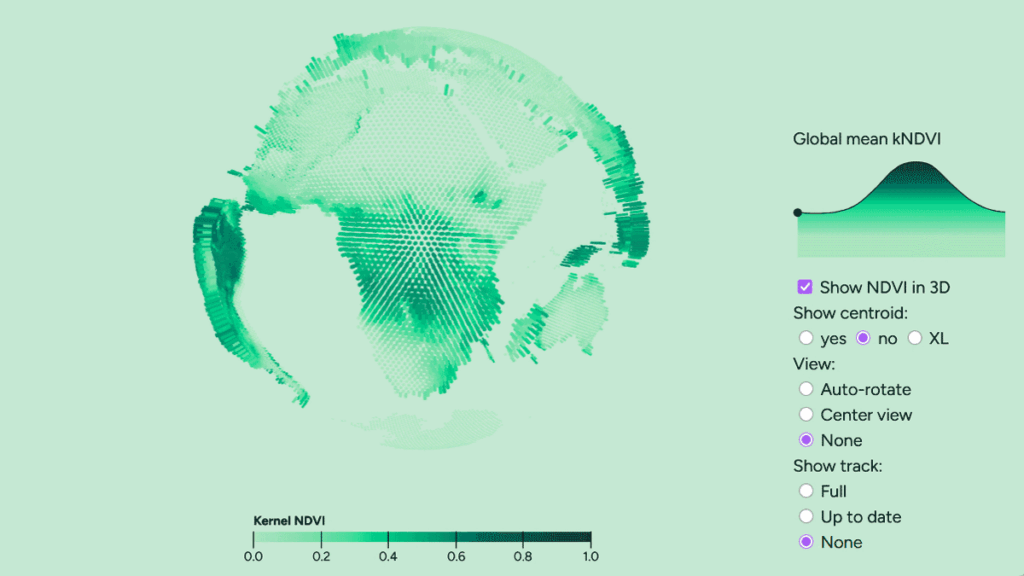
Now, in a study published in Proceedings of the National Academy of Sciences of the United States of America, researchers analyzed 40 years of this green wave data and tracked the center of mass of global greenness—essentially the average location of vegetation on Earth, giving more weight to greener areas. They found that this center has been shifting northward and eastward and that this movement has accelerated over the past decade.
“Climate change is not just about global mean temperatures. Together with land use change, it is reorganizing how the biosphere works,” said Miguel D. Mahecha, an environmental data scientist at Universität Leipzig and lead author of the study. “Becoming greener is [often considered] good, but it is actually a sign of global change.”
A Serendipitous Idea
Mahecha was preparing for a public talk among visitors and politicians for a day of science event. He had a video of global satellite images of seasonal greenness changing through the years, and he wanted to explain why his team was working on this problem. But “somehow it didn’t really fascinate people that much,” he said.
During casual rehearsal among friends and family, Mahecha realized he could explain the idea more intuitively by telling them to imagine a perfectly round soccer ball being thrown into a water tank. “At a certain point, [the floating ball] would stand still, [having] a point facing to the bottom,” he said. The next time you threw it in, a different random point may face to the bottom.
But if a map of the world were printed on that ball, along with extra weight where the green biomass is highest, then the ball would no longer be symmetrical. The part with the heaviest biomass would tip downward. “So I imagined that you reprint this 3D ball every day. Then this point [tipping downward] is going to change,” he added.
To track the movement of the centroid of this greenness, researchers used long-term global datasets, including those of vegetation greenness, leaf area, and carbon dioxide uptake. They then computed the center of mass for each of them, tracking the centroid in 3D vectors as it shifted in position, seasonal timing, and transitions.
“I think the surprising result was not that the centroid is moving north, because we expected that from global greening, but that it is moving so much to the east.”
“I think the surprising result was not that the centroid is moving north, because we expected that from global greening,” Mahecha said, “but that it is moving so much to the east.”
The team also found that the swing of this green wave seems actually to be shrinking between the hemispheres. “The centroid is expected to move south during the southern summer,” Mahecha said, “but in fact, we found the southern summer [peak] is also going north.” He explained that intense drought might be driving this change in the Southern Hemisphere, whereas shorter winters and a longer growing season are driving the change in the north.
“I think this is quite a clever study,” said Dennis Baldocchi, a biometeorologist and professor emeritus at the University of California, Berkeley. The study managed to find a simple way to distill a vast amount of information into something that could be easily visualized, he said. The researchers have also launched an easy-to-navigate website, greenwave.earth, for people to interact with and visualize the study data.
Humans are living in a world now with rising carbon dioxide, warming temperature, booms and busts, and rainfall at different locations and different times. “So this method helps integrate all these and comes up with some simple numbers that show the change in trajectories over space and time,” Baldocchi said.
The researchers said similar wave visualizations can be created at the scale of countries and regions, providing ways to measure weather regions or to measure productivity of cities and prepare for future adaptations. The method can be transferred to different disciplines too. “You can calculate the white wave for ice or blue wave for soil moisture too,” Mahecha said.
—Saugat Bolakhe (@saugat_optimist), Science Writer
Citation: Bolakhe, S. (2026), Earth’s “green wave” is on the move, Eos, 107, https://doi.org/10.1029/2026EO260093. Published on 19 March 2026.
Text © 2026. The authors. CC BY-NC-ND 3.0
Except where otherwise noted, images are subject to copyright. Any reuse without express permission from the copyright owner is prohibited.