As climate change accelerates, it’s more important than ever to understand the individual drivers of sea level rise, from land subsidence and coastal erosion to changes in ocean volume. For the past 20 years, scientists have had access to high-resolution, satellite-derived maps of Earth’s gravity field, which allows them to calculate fluctuations in global ocean mass.
Recently, geodesists have found a way to extend that record back 10 more years, significantly extending the time frame by which they can consistently measure global ocean mass change.
“This is the first observation-based global ocean mass time series” from 1993 to the present, said Jianli Chen, a geodesy researcher at Hong Kong Polytechnic University in China and a coauthor on the research.
By reconciling older and newer techniques for measuring ocean mass change, the team’s work improves calculations of long-term trends and provides a potential stopgap should satellite data no longer be available.
Shooting Lasers into Space
When scientists measure sea level rise, they consider two main components: how much the ocean’s volume has grown because of changes in water density—the steric component—and how much it has grown because it has gained mass from melted ice—the barystatic component.
Past estimates of total ocean mass change have relied on indirect methods like adding up mass loss from ice sheets, glaciers, and land water storage, explained Yufeng Nie, a geodesy researcher also at Hong Kong Polytechnic University and lead researcher on the new study. Mass lost from these areas is assumed to translate to an increase in ocean mass.
“But these individual estimates are not necessarily consistent, because they are developed by different groups” with different methodologies, Nie said.
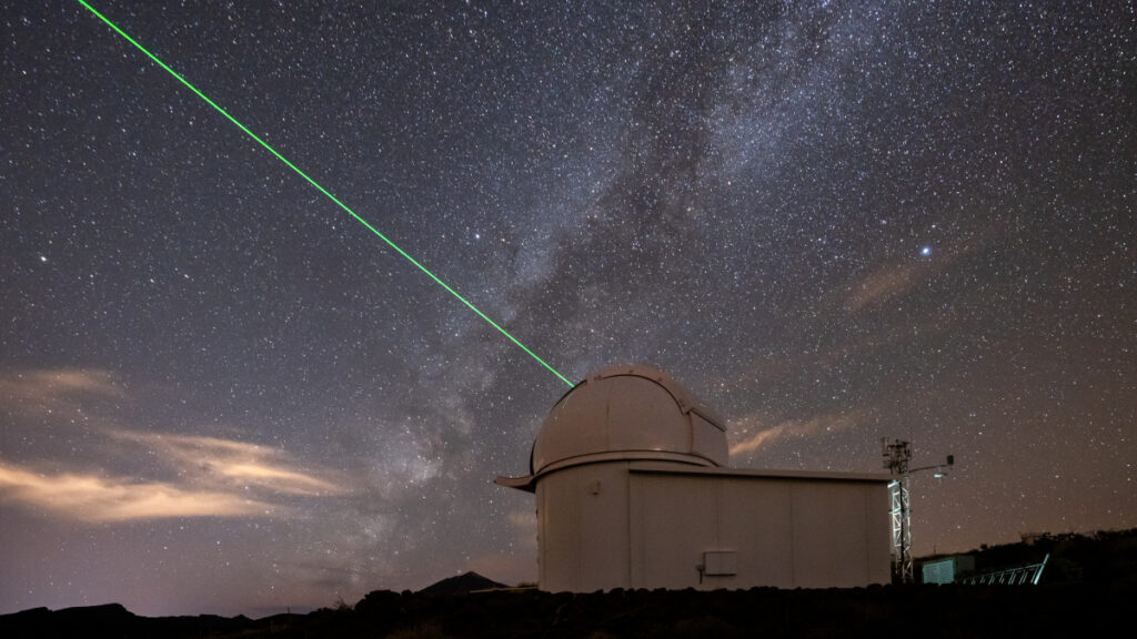
In light of this, some researchers adapted satellite laser ranging (SLR), a technique in which scientists bounce ground-based lasers off orbiting satellites to track changes in ocean mass. SLR has been used for decades to measure Earth’s nonuniform gravity field by observing shifts in satellite orbits. A satellite’s altitude depends on Earth’s gravity at any given point, and gravity in turn depends on the distribution of mass beneath that point. Measuring satellite altitudes thus provides a window into measuring ocean mass changes.
“How can you observe, for example, ocean mass change from Antarctic melting using a technique with 4,000-kilometer spatial resolution?”
However, one key drawback to using SLR to measure barystatic sea level (BSL) change is that it can measure changes only on very large spatial scales, which limits its application in climate research, Chen said.
“How can you observe, for example, ocean mass change from Antarctic melting using a technique with 4,000-kilometer spatial resolution?” asked Chen.
Enter NASA’s Gravity Recovery and Climate Experiment (GRACE) missions. GRACE and its successor, GRACE Follow-On (GRACE-FO), each consisted of two satellites chasing each other along the same orbit, continuously sending laser beams back and forth. Like SLR, this process allowed the GRACE missions to provide maps of Earth’s surface mass, but at 10 times the resolution of SLR. And like with SLR, scientists have used GRACE gravity maps to track global ocean mass change.
But GRACE data, too, have their caveats. The first GRACE mission spanned 2002–2017, and GRACE-FO has spanned from 2018 to the present, a short time for understanding long-term trends. What’s more, the 11-month gap between GRACE and its successor meant that scientists were not able to calibrate the two satellites with each other, leaving some uncertainty about systematic differences between the missions.
A Near-Perfect Match
Nie, Chen, and their team were able to address both of these caveats by comparing SLR-based measurements of global ocean mass change with those from GRACE/-FO for the same time period, 2003–2022.
According to gravity maps provided by SLR, barystatic sea level change was 2.16 millimeters per year from 2003 to 2022, while GRACE/-FO measured 2.13 millimeters per year.
The new analysis shows that SLR and GRACE/-FO “agree quite well for the long-term trends,” Nie said. What’s more, researchers found no significant change in the calculation when the data transitioned from GRACE to GRACE-FO. “This gives us confidence that the SLR data, although it is of very low spatial resolution, can be used to tell us the ocean mass variations before 2002,” he added.
“Our SLR measurements…can provide a global constraint of the mass changes for the pre-GRACE era.”
The researchers were able to extend the time frame of their analysis back to 1993 by using SLR data, and they calculated a barystatic sea level change of 1.75 millimeters per year for 1993–2022. They attribute the lower rate of sea level rise in the past to recent acceleration of ice loss in Greenland.
“Our SLR measurements…can provide a global constraint of the mass changes for the pre-GRACE era,” Nie said.
This study was published in Proceedings of the National Academy of Sciences of the United States of America in June.
“Extending the record of measured BSL using satellite laser ranging back to 1993 is an important achievement,” said Bryant Loomis, chief of the Geodesy and Geophysics Laboratory at NASA’s Goddard Space Flight Center in Greenbelt, Md. “It allows the disaggregation of total sea level change, which is measurement by altimetry, into its barystatic and steric components.”
“The long-term BSL estimate is also useful for assessing the accuracy of previous efforts to quantify the major land ice contributions to BSL prior to the launch of GRACE,” he added, referring to the method of adding together mass changes from glaciers, ice sheets, and land water storage. Loomis was not involved in the new research.
Nie, Chen, and their team are working to push the limits of SLR-derived barystatic sea level measurements to smaller spatial scales and lower uncertainties. They hope to demonstrate that SLR data can be used to measure mass change in Antarctica.
GRACE Continuity?
GRACE-FO launched in 2018 and is 7 years into its nominal 5-year mission. The satellites are in good health, and the nearly identical GRACE mission set a good precedent—it lived for more than 15 years. GRACE-FO might well overlap with its planned successor, GRACE-Continuity (GRACE-C), which is scheduled to launch in 2028.
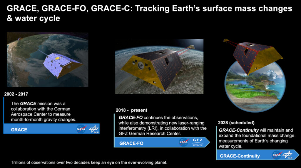
However, recent woes for federally funded science in the United States have put GRACE-C’s future in doubt. Although NASA requested funding for GRACE-C for fiscal year 2026 through the mission’s launch, NASA’s acting administrator, Sean Duffy, recently stated his, and presumably President Donald Trump’s, desire to eliminate all Earth science at the agency (including healthy satellites). That cutback would likely nix GRACE-C.
In the near future, both Europe and China plan to launch satellite-to-satellite laser ranging missions that will provide GRACE-like measurements of Earth’s gravity, Chen said. However, the loss of GRACE-quality data would hamper climate scientists’ ability to accurately track drivers of sea level rise, he added. The SLR-derived measurements demonstrated in this recent research could help mitigate the loss, but only somewhat.
“There’s no way SLR can reach the same [resolution] as GRACE,” Chen said. “We can only use SLR to see the long-term, the largest scale, to fill the gap. But for many of GRACE’s applications—regional water storage or glacial mass change—no, there’s no way SLR can help.”
—Kimberly M. S. Cartier (@astrokimcartier.bsky.social), Staff Writer
Citation: Cartier, K. M. S. (2025), Bridging old and new gravity data adds 10 years to sea level record, Eos, 106, https://doi.org/10.1029/2025EO250321. Published on 3 September 2025.
Text © 2025. The authors. CC BY-NC-ND 3.0
Except where otherwise noted, images are subject to copyright. Any reuse without express permission from the copyright owner is prohibited.