
30 people have been evacuated in Les Epenays and Fregnoley in the Val de Bagnes in Valais due to the threat of debris flows .

As the dust settles on the landslide crisis at Blatten, Swissinfo has published a very nice article highlighting the growing landslide risk in Switzerland. For example, in the canton of Graubünden (which is the focus of the article) alone, 17,000 buildings are located in high natural hazard areas. Over 5,000 of these are residential properties.
Right on cue, another significant landslide crisis has developed in Switzerland, this time in in the upper Val de Bagnes in Valais. Here, an ongoing slope collapse is generating debris flows that are affecting the village of Les Epenays. Thirty people have been evacuated. Blue News has published a nice article that summarises the threat. Parts of another hamlet, Fregnoley, are also at some risk, and two farms have been evacuated there as well.
The evolution of this crisis is best told with a series of Planet Labs satellite images. So, to start, this is the site on 28 June 2024. The marker, which is located at [46.06612, 7.26522], is in the upper part of the catchment that is causing the problems.

This is a typical alpine subcatchment, with steep upper slopes and some incision. How let’s jump forward a week to 5 July 2024:-

The site had dramatically changed, the result of intense rainfall. In the upper part of this subcatchment, slope failure had occurred. Lower down the slope a large alluvial fan has developed, and the image shows that the road has been inundated. Further debris flows occurred through summer 2024.
In the last week, storms have further exacerbated the issues. This is an image collected on 8 June 2025:-

Note the dramatic increase in instability in the upper portions of the catchment (especially in the area of the marker) and the huge area inundated by the debris flows downstream. This acceleration in activity was driven by a storm on 1 June 2025.
It is interesting to compare the June 2024 and June 2025 images:-


What a difference a year makes!
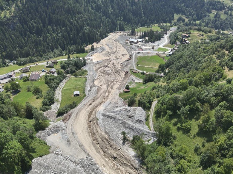
The Commune of Val de Bagnes has also released this image of the impact of the debris flows on the road:-

The Commune of Val de Bagnes is publishing daily updates. The bulletin published yesterday highlighted that the slopes in the upper catchment that are generating these debris flows are currently moving at up to 2 metres per day.
Clearly, this issue is less acute than the one at Blatten, but it is serious headache nonetheless. The Alps are prone to thunderstorms with intense rainfall in the summer months, so this could be a trying period for the local community and for the authorities in Vallais.
Acknowledgement and reference
Thanks to loyal reader Alasdair MacKenzie for highlighting the article on landslide risk in Graubünden. And thanks also to Planet Labs for their wonderful imagery, again.
Planet Team 2025. Planet Application Program Interface: In Space for Life on Earth. San Francisco, CA. https://www.planet.com/
Text © 2023. The authors. CC BY-NC-ND 3.0
Except where otherwise noted, images are subject to copyright. Any reuse without express permission from the copyright owner is prohibited.