
A new paper (Faral et al. 2025) provides details of a seismically-triggered landslide cascade and tsunami that killed up to 12,000 people.

On 22 November 1815, a very significant landslide disaster occurred in Bali, in what is now Indonesia, killing between 10,000 and 12,000 people. A very interesting new paper (Faral et al. 2025) in the journal Geomorphology has sought to investigate and understand this catastrophe.
The event, which occurred on Buyan-Bratan caldera, was triggered by the Mw=7.3 1815 Bali earthquake offshore. This triggered a translational landslide near the peak of the caldera. To provide a context, this is a Google Earth image of the site:-

This image shows the steep caldera at the top, with the steep slopes down to the sea.
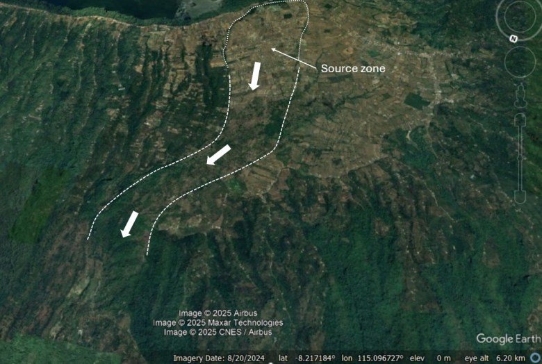
Faral et al. (2025) have identified the location of the initial failure. This is surprisingly clear on the Google Earth imagery:-

The failure was a translational landslide – the source zone is so clear because it was left steep slopes in the rear scar and the lateral scarps, which now have dense vegetation. These lateral scarps are 30 to 35 m tall, delineating a landslide with a source area of 2.38 km2 and a volume of about 64 million cubic metres. Descriptions of the event highlight that the area had been subject to “intense and prolonged rainfall”, which may have contributed to the instability.
Faral et al. (2025) have undertaken detailed work to understand the characteristics of the landslide as it travelled the c.17 km to the coast. I think the initial path is quite easy to spot on the imagery:-

Lower down the path becomes much less clear, but Faral et al. (2025) have used a range of mapping and stratigraphic techniques to try to understand it. In an earlier paper (Faral et al. 2024), the team has also mapped the c.15 villages that historical records indicate were destroyed by the landslide. They conclude that the initial failure transitioned into a debris avalanche and then a debris flow, eroding saturated sediment from the lower slopes and spreading laterally. This huge landslide moved enormous blocks of rock – one of which is 9 metres long for example – that are now scattered on the lower slopes.
Eventually the landslide reached the sea, and there are reports of a local tsunami. Faral et al. (2025) psotualte that this was most likely generated by the landslide rather than by the original earthquake. They note that there are no known deposits from the tsunami, which supports the notion of a smaller, localised event.
The 22 November 1815 Gejer Bali disaster was a very significant event that warrants more attention – I thank the authors of the two papers from highlighting and investigating this most fascinating disaster. I’m left pondering how we could anticipate a similar event. The nature of this type of initial failure seems hard to determine in advance, given its seismic origin, and the behaviour of the flow is also very difficult to forecast. Thus, such events represent a massive challenge in managing landslide risk.
References
Faral, A., Lavigne, F., Sastrawan, W.J. et al. 2024. Deadliest natural disaster in Balinese history in November 1815 revealed by Western and Indonesian written sources. Natural Hazards 120, 12011–12041 (2024). https://doi.org/10.1007/s11069-024-06671-5.
Faral, A. et al. 2025. Field evidence of the greatest disaster in Balinese history: The 1815 Geger Bali multi-hazard event in Buleleng. Geomorphology, https://doi.org/10.1016/j.geomorph.2025.109903.
Text © 2023. The authors. CC BY-NC-ND 3.0
Except where otherwise noted, images are subject to copyright. Any reuse without express permission from the copyright owner is prohibited.