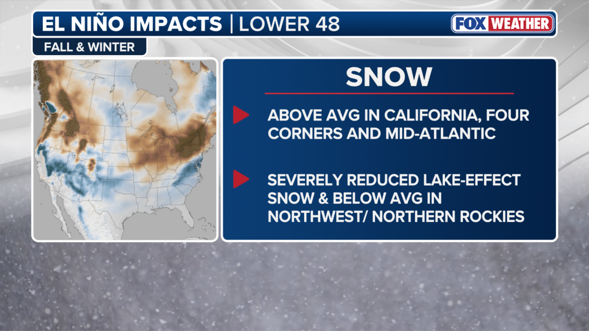
A record-strength El Niño is tilting this winter’s snow odds toward three parts of the country in a new outlook from Fox Weather. Forecasters at NOAA’s Climate Prediction Center, part of the National Weather Service, give the event an 83 percent chance of becoming the strongest on record, and the southern storm track it favors has stayed unusually active through the fall. That could mean snow on roads where drivers get only a few wintry days in a typical year.
Where Above-Average Snow Is Possible This Winter
California, the Four Corners and the Mid-Atlantic are the three regions shown for above-average snow on a map in Fox Weather’s November 4 winter outlook, with an active subtropical jet stream expected to keep storms moving across the southern half of the country. The same jet steered several systems over the Southwest in the fall, and the forecaster puts rainfall across the Four Corners at 8 to 16 inches above average for the season so far. The National Weather Service’s El Niño discussion expects a strong to very strong event to hold through January to March 2027, which covers the heart of the snow season.
Snow in the Mid-Atlantic still needs cold air in place when a storm arrives, so a busy jet improves the odds there without guaranteeing a snowy winter. Fox Weather reports Pacific water temperatures about 2.67 degrees Celsius above average and calls this the warmest Super El Niño on record. The forecaster uses that label once anomalies reach at least 2 degrees above normal.
Where Snow Could Come Up Short
Below-average snow is possible in the Rockies and the Pacific Northwest, according to Fox Weather, and lake-effect snow downwind of the Great Lakes may be substantially reduced. NOAA’s winter outlook does not forecast snowfall at all, but its temperature and precipitation maps favor warmer than average temperatures across the Pacific Northwest and northern Rockies and drier than average conditions in parts of the northern Rockies and Great Lakes. Fox Weather expects the Northern Tier to run warm while the South and Gulf Coast turn cooler, with most of the season’s extra precipitation falling across the southern U.S.
What A Southern Storm Track Means For Snow Drivers
A cooler South with more moisture moving through it raises the chance of snow reaching drivers who see it only a few times a year. In an earlier winter breakdown, Fox Weather described a moisture corridor from the Southern Plains to the Mid-Atlantic with higher odds of coastal nor’easters, and warned that high-impact winter storms could form if cold air pushes far enough south to meet it. In the Mid-Atlantic, a winter like that tends to bring snow in a handful of large storms instead of frequent light ones, and a single big storm puts commuters, delivery trucks and plows on the same roads at the same time.
Storms of this kind often drop snow at temperatures close to freezing, and that snow is heavy and wet. Tires pack it into slush that refreezes overnight, it collects in wheel wells and on wiper blades, and the morning after a storm can be harder to drive than the storm itself. All-wheel drive helps a car pull away on that surface. Stopping depends mostly on the tires and the condition of the road, which leaves following distance as the part a driver controls most directly.
Northern Drivers And A Lighter Lake-Effect Season
Fewer snowy commutes are possible across the Great Lakes if the warm, lake-effect-light forecast holds, but the Fox Forecast Center points out that even in regions with poor seasonal odds, “individual outbreaks can still produce big storms.” A warm-leaning forecast can also make winter tires look optional, particularly for drivers weighing whether a worn set of all-seasons will last another year. The tread compound on an all-season tire stiffens as temperatures fall, and the cold mornings that still turn up in a mild winter are when that difference shows.