Snow has already started, and the heaviest totals are still ahead. The National Weather Service’s high-end forecast reaches up to 36 inches in spots by Friday evening, with gusts near 50 mph. For drivers, that matters because state transportation officials can put traction rules into effect on any state highway during a storm.
The Snowfall Forecast
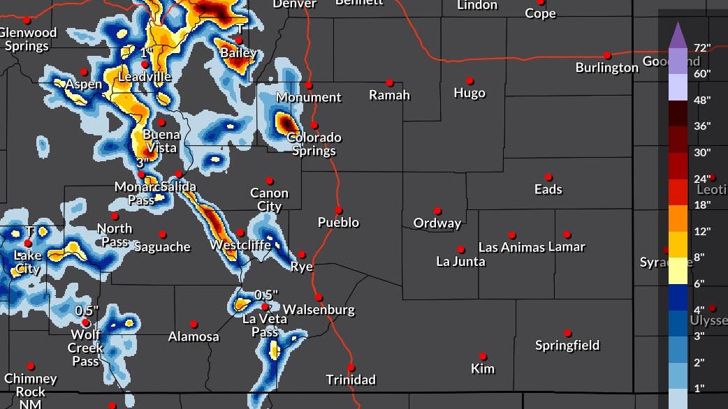
Pikes Peak carries the heaviest totals, with the core of the forecast reaching 36 inches, and the Front Range west of Denver is close behind at 30 to 36 inches. Those figures come from the high-end projection NWS Pueblo issued at 2:15 a.m. ET Wednesday, which runs through 8 p.m. ET Friday. The Sangre de Cristo Mountains near Westcliffe and the area near Bailey fall in the 18- to 30-inch range. A wider band of 12 to 18 inches runs down the Sawatch Range from Leadville past Buena Vista toward Monarch Pass, with 8 to 12 inches in the San Juans near Lake City. There is a 1 in 10 chance totals end up higher than the map shows. The version Autoblog covered earlier this week, which ended Thursday morning, topped out at 8 inches.
The office’s latest Hazardous Weather Outlook, issued early Wednesday, expects several inches of snow on the higher peaks above 12,000 feet through tonight, as the remnants of a tropical storm system spread across southern Colorado.
National Weather Service Pueblo
Colorado meteorologist Luke Victor, who shared his forecast on Facebook, lands on the same timing. He expects heavy snow in the Colorado mountains on Thursday as an upper-level low pivots east, and wrote that forecast guidance shows 6 to 12 inches or more across the Sangre de Cristo, Wet, San Juan, Sawatch and Front ranges by Thursday morning, while cautioning that totals above a foot were not yet a safe bet given the uncertainty in the storm track.
The map he posted measures something different. It shows projected snowfall totals for the full week, from Sunday, Sept. 27, into the early hours of Sunday, Oct. 4, so it covers several days beyond his Thursday forecast. Its heaviest shading runs along the Front Range west of Denver and Castle Rock, through the San Juans north of Durango, and down the Sangres toward Trinidad.
Road Conditions
NWS Pueblo expects north winds gusting around 45 mph at times across the region from tonight into early Thursday. On the highest terrain it is stronger, with the office’s zone forecast for Pikes Peak above 11,000 feet, calling for gusts around 50 mph tonight and again on Thursday, along with up to 3 inches of snow today and about 4 more tonight.
The heaviest-shaded part of Victor’s Front Range forecast includes I-70 and US 285 west of Denver. I-70 between Dotsero and Morrison entered the seasonal window of Colorado’s Passenger Vehicle Traction Law on Sept. 1, so its tire requirements can be enforced there as soon as CDOT activates the law during a storm, with notice on highway signs and COtrip.org.
If conditions worsen, CDOT can move to its stricter Chain Law, which requires every vehicle to carry chains or an approved alternative such as an AutoSock. At that stage all-wheel drive and a good set of tires no longer qualify on their own.