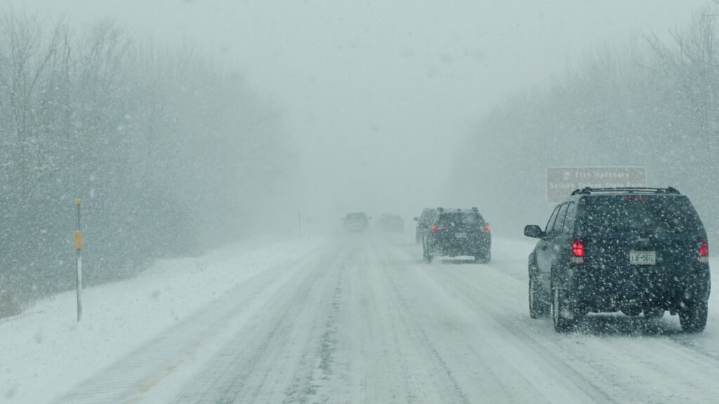
Winter is not done with New England. A potent late-season system is pushing a wintry mix of rain, sleet, and snow across the region today, delivering hazardous driving conditions along some of the Northeast’s most heavily traveled highway corridors. The National Weather Service Boston/Norton office flagged two distinct hazard windows for Monday: a morning round of sleet and wet snow mixing in along and north of I-90, followed by a second round of scattered snow squalls expected through midnight.
The Primary Threat: Wintry Mix and Morning Commute Hazards Along I-90
The immediate threat is concentrated along the Massachusetts Turnpike corridor and points north. NWS Boston forecasters specifically flagged the potential for increased snow and sleet accumulation along I-90 during the morning commute hours, warning of slushy surfaces even where precipitation is lighter. Rain has been mixing with sleet and wet snow near and north of the Pike since before dawn.
Where the heavier precipitation bands materialize, brief accumulations of up to 2 inches are possible on paved surfaces near the I-90 corridor. That threshold may sound modest, but wet, heavy late-season snow on a commuter highway carrying significant truck traffic is not a minor event. Temperatures are holding in the low-to-mid 30s across central Massachusetts, exactly the marginal range where road surfaces can transition from wet to slushy with little warning.
Related: I Drove The Mini Cooper JCW Here’s My Honest Review
The Secondary System: Squalls Push North Through New England
The heavier totals are tracking toward northern New England, where NWS forecasters and the Weather Prediction Center have been tracking the development of an inverted trough extending back from a departing low. That feature is expected to focus a north-south band of snow showers across eastern New England, capable of intensifying into squall conditions late Monday as an incoming shortwave trough sweeps in from the west.
Northern New Hampshire and western Maine are in the highest-impact zone, with totals in the 3 to 6 inch range forecast by NWS across that corridor, and localized pockets pushing higher in the extreme north. Visibility in the heaviest squall bands can drop to near zero in minutes.
Regional Specifics: Named Highways and Passes at Risk
I-90, the Mass Pike, carries tens of thousands of vehicles daily through the snowbelt north of Worcester and into the Berkshires. Today it is the primary highway hazard zone south of the New Hampshire border. North of the Pike, US-3, I-93, I-89, and I-95 through New Hampshire and Maine are all tracking inside the squall risk zone through tonight. In northern Maine, roads including US-2 and the Interstate 95 corridor through Bangor and beyond should be treated as hazardous through the overnight hours.
The second squall window: NWS Boston places it from late afternoon through midnight, which coincides with the PM commute for much of the region. This is the most dangerous timing combination on any winter weather day: roads that appear merely wet from an afternoon squall can refreeze rapidly once temperatures drop into the upper 20s overnight, turning slushy pavement into a black ice surface with no visible warning for drivers.
What Drivers Should Know
The first question on a day like this is whether the trip is necessary. If you are driving in northern New Hampshire or Maine today, that calculus is simple: delay until the squall window passes after midnight if your schedule allows.
For drivers who must travel the I-90 corridor or US-3 north through Concord and Manchester, reduce your speed well below posted limits. Late-season snow is wet and heavy and can accumulate on road surfaces faster than highway crews can treat them.
Black ice is the overnight threat. Any pavement that is wet at sunset in the 33-35 degree range will be ice by 9 PM as temperatures fall into the high 20s. If you are driving New England interstates after dark tonight, assume the road surface is compromised and give yourself triple the normal stopping distance.
Winter Driving Tips: What to Know Before You Hit the Road
Slow down and turn off cruise control. This is non-negotiable on a squall day. As Autoblog’s guide to driving in snow, ice, and rain makes clear, cruise control cannot react to the sudden traction loss that a squall line can cause, and it can make a slide worse. Drop your speed well below posted limits and drive the road, not the GPS arrival time.
Your tires are the variable that matters most. All-wheel drive helps you go, it does nothing to help you stop. Autoblog’s winter car readiness checklist recommends a minimum of 4/32 inches of tread for safe winter driving, and notes that cold weather reduces tire pressure at a rate of roughly 1 to 2 PSI for every 10-degree temperature drop. Check your pressures before you leave this morning. If you’re still running all-seasons and live north of the Pike, Autoblog’s full breakdown of the best cars and SUVs for snow and winter driving is worth bookmarking, but the short answer is that the right tires matter more than the right vehicle.
Give yourself triple the stopping distance. On wet pavement transitioning to slush or ice, the stopping distance for an average passenger vehicle can increase by 300 percent or more compared to dry road conditions. If the car ahead of you brakes hard and you’re following at a normal dry-weather gap, you will not stop in time.