As the holiday weekend wraps up, the National Weather Service (NWS) is warning of severe weather slamming into Northern California starting today, Monday, Feb. 16, and running through Wednesday, Feb. 18. The NWS has issued a suite of wind advisories and flood watches for the San Francisco Bay Area, with weather experts warning of a dynamic storm system on track to bring damaging winds and significant rainfall to the region.
Gemini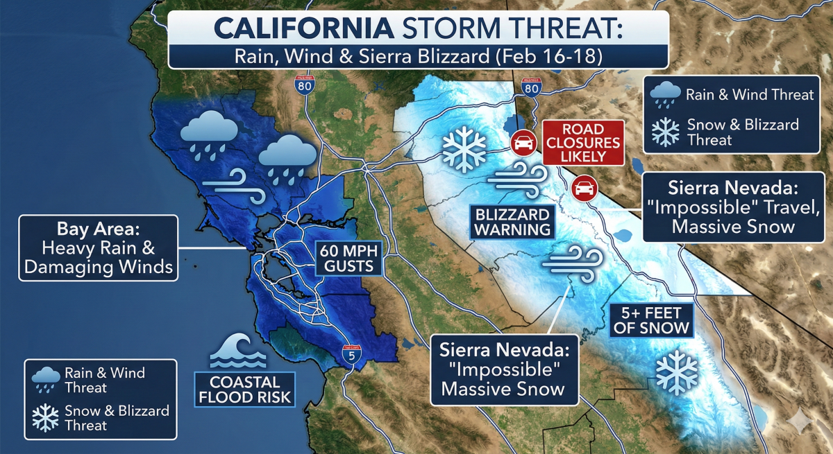
Bay Area Looking at 60 MPH Winds and Flooding
Specifically, NWS forecasts indicate wind gusts could reach dangerous levels along the coast. According to a report from the NWS Bay Area office, “Southwest winds of 25 to 35 mph with gusts up to 50 mph are expected, locally up to 60 mph above 2,000 feet.” They add that, “Gusty winds will blow around unsecured objects. Tree limbs could be blown down, and a few power outages may result.”
The storm is estimated to bring steady moderate-to-heavy rainfall, which will saturate soils and increase the risk of shallow landslides. “Residents were urged to exercise extreme caution on the roads and apply the golden rule when encountering a flooded roadway: ‘Turn around, don’t drown,'” warns a local update from CBS News Bay Area. “It only takes a small amount of moving water to sweep a vehicle off the road.”
Sierra Nevada Mountains Warned of “Impossible” Travel
The NWS also warns that while the coast gets rain, the mountains will get buried. “A winter storm warning was issued from 10 p.m. Monday through 10 p.m. Wednesday, with heavy snow expected,” reports CBS News. The NWS adds, “Heavy winds with gusts of up to 55 mph are expected, resulting in dangerous to near-impossible travel conditions with chain controls and road closures.” Snow totals are expected to be massive, with forecasters predicting “up to a foot from 1,500 to 2,500 feet, 1 to 2 feet at 2,500 to 3,500 feet, and 4 to 8 feet of snow at higher elevations.”
Coastal Flooding Risks High Tides
If you think the wind is the only issue, the ocean has other plans. The NWS shared that a “Coastal Flood Advisory is in effect through Tuesday for minor high tide flooding.” They also note that, “The combination of spring tides and storm surge will bring minor high tide flooding to the San Francisco Bay and Monterey Bay through Tuesday. Up to 1.0 ft of inundation is expected in the San Francisco Bay.”
Tires and High-Profile Hazards
For drivers navigating the Bay Area’s wind-swept bridges, vehicle profile matters. The National Weather Service warns that high-profile vehicles, such as SUVs, trucks, and vans, are particularly vulnerable to predicted 60 mph gusts.
Keep a firm grip on the wheel, as wind can easily push larger vehicles out of their lanes, especially on highway overpasses, tunnels, and ‘road cuts’ through mountainous areas that can act as funnels for wind.
The “Quarter Test” and Wet Weather Grip
When driving in heavy rain, your tread depth is the only thing preventing hydroplaning. While the legal minimum for tire tread depth is 2/32 of an inch, automotive experts such as Tire Rack and AAA warn that this is unsafe on wet roads and recommend replacing at 4/32 of an inch. “Tests show that tires worn to 4/32 of an inch can take up to 87 feet longer to stop from 60 mph compared to new tires,” reports AAA.
To check your tires instantly, skip the “penny test” and use a quarter. Insert the coin into a tread groove with Washington’s head facing down; if you can see the top of his head, your tread is below 4/32 of an inch, and your risk of hydroplaning has increased significantly.
Additionally, not all tread patterns are equal. For maximum water evacuation, look for “directional” tread patterns with V-shaped grooves that resemble arrowheads, engineered to slice through standing water and push it outward more efficiently than standard symmetrical tires.
Related: I Drove the 2026 Lexus RX 450h+ Luxury. This is My Honest Review