Lake Victoria, Africa’s largest lake, supports a quarter of East Africa’s population with fish, fresh water, and critical transportation routes. It’s also one of the deadliest bodies of water in the world.
Storms, high winds, and waves frequently capsize boats, causing thousands of deaths each year.
Despite the hazard, Lake Victoria has historically lacked enough weather observation stations to provide a clear picture of weather patterns in the region. Overly general and often inaccurate forecasts have meant that those heading out on the water had little idea what weather they’d face.
In 2017, the World Meteorological Organization (WMO), the weather agency of the United Nations, began a multiyear effort to improve weather information for the lake and establish early-warning systems for life-threatening storms. Now, much of the lakeside population uses the program’s tailored forecasts, leading to an estimated 30% reduction in weather-related deaths on the lake.
Still, a dearth of weather data persists across the continent. Because of ongoing economic depression, conflict, and disruptive weather patterns, Africa has gone decades without observational networks that meet international standards.
Today, the continent has the least dense weather observation network in the world. The average density of stations meeting WMO standards is 8 times lower than the WMO recommended level; more reporting surface stations exist in Germany than across all of Africa, according to the WMO and the World Bank.
The lack of observations often leaves communities without early warnings of natural disasters, cripples forecasts that farmers rely on, and leaves scientists who are studying global climate and weather with a major data gap.
In 2019, the need for improved weather networks around the world was recognized at the Eighteenth World Meteorological Congress in Geneva, Switzerland. There, the WMO’s 193 member states and territories established the Global Basic Observing Network (GBON), an international agreement that specifies requirements for weather data collection, including which parameters to measure, when and at what resolution to measure them, and how to share the data between countries.
With encouragement from the WMO and smaller organizations, national meteorological agencies in Africa are also recognizing the need for enhanced weather and climate services and planning for them, said Zablon Shilenje, the technical coordinator of services for the WMO’s Regional Office for Africa.
That recognition, combined with increased economic investment, has slowly led to weather stations being added to networks throughout Africa.
“The situation now has improved a lot,” said Frank Annor, a water resources expert at TU Delft and Kwame Nkrumah University of Science and Technology in Ghana. But the continent is still far from meeting GBON reporting standards. And in the face of an ever more variable climate, additional investments and improved ways of working together are needed.
“There is a huge gap, and we need to work on it,” Shilenje said.
Scarce Stations
Climate models used by scientists and forecasts created by meteorologists fundamentally rely on current and past weather data, particularly temperature and precipitation measurements, to extrapolate patterns into the future. “Any time the historical information isn’t perfect, that’s going to cause potential issues,” especially for estimating the impacts of climate change, said Pascal Polonik, a climate scientist at Stanford University.
Forecast accuracy declines as the number of observations drop. That’s particularly problematic when an entire region or large swaths of it have little to no observational data—as is the case in many parts of Africa.
“We lack the ground data. That data is not being ingested into models, so then when you do predictions, your predictions are less accurate.”
“We lack the ground data. That data is not being ingested into models, so then when you do predictions, your predictions are less accurate,” Annor said.
There wasn’t always such a lack of station density. In the first half of the 20th century, African countries’ networks were growing on par with those in other parts of the world, though they never reached the same densities as in places like North America. But now, Africa has less than one third of the weather stations that it once had.
Social and political conflict is one reason for the decline. One 2019 analysis of temperature records available in sub-Saharan Africa found that a country’s civil conflict risk was negatively correlated with both the number and density of weather stations contributing to its temperature record.
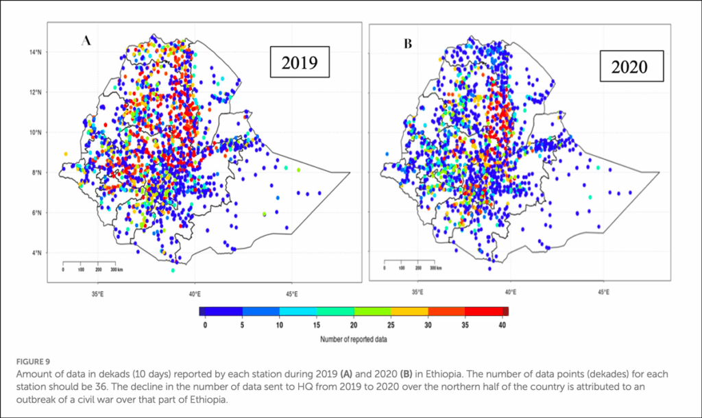
Some conflicts or social upheavals have had an outsized effect on monitoring networks. During and after the 1994 genocide in Rwanda, for instance, the average number of actively reporting weather stations in the country dropped from more than 50 to less than 10. Nearly 15 years passed before station coverage returned to preconflict levels. In another instance, station density in Uganda declined from a peak of about 500 stations following independence in the 1960s to less than 100 by 2001. A civil war in Ethiopia beginning in 2018 resulted in a sharp decline in reporting weather stations in the northwest part of the country, where much of the fighting took place.
“You can see from one year to another how unrest can affect station density,” said Tufa Dinku, a senior research scientist at the Columbia Climate School in New York.
Beyond conflict and the challenges of establishing a stable national government, a lack of economic resources has also contributed to the drop in weather station density. In the late 1980s and 1990s, Africa entered an economic depression that made it difficult for states to update their weather observational systems with technology on par with that used by countries in Europe and North America.
“African countries were not able to recover their meteorological [networks],” said David Mburu, who worked for more than 30 years as a meteorologist at the Kenya Meteorological Department.
Weather itself is partly to blame for slow economic development: Climate variability has caused frequent droughts, floods, heat waves, and land degradation, Dinku wrote in a 2006 article exploring the challenges of managing climate change on the continent.
The places in the world that are most affected by climate change tend to overlap with places in the world that are economically poor and, often, also data poor, Polonik said.
Shilenje said climate change only adds to the challenge of maintaining networks, affecting the durability of the instruments and equipment used to make observations. “There is a strong correlation between climate change and the ability to maintain a stable observing network on the continent,” he said.
A Dearth of Data
The reporting weather stations that do exist are often located along roads or concentrated in urban areas, meaning they’re not dispersed well enough to give an accurate reflection of weather across a whole country or region, Dinku said. Weather station coverage tends to be worse in rural areas, where better weather and forecasting information is most needed.
The dearth of observational stations has far-reaching consequences for Africans and those doing business there. Farming, for example, makes up about 15% of the continent’s economy. Without accurate forecasts, farmers are left without the information they need to make decisions about how to keep their livelihoods afloat.
“If you don’t know when it’s going to rain or how much to expect, then how do you go about your agriculture activities? That is the problem,” Annor said.
Inaccurate accounting of rainfall also means some farmers struggle to get their insurance claims paid, he said. “People then don’t want to invest in insurance again,” Annor said. “What that means is that people take calculated risk: They minimize the amount of food they can grow so they can minimize their risk.”
“The data from Ethiopia is not just for Ethiopia. The more observations you have in Africa, the better forecast we’ll have anywhere else in the world.”
The observations lost over the past few decades didn’t just limit forecasts then: The holes in the data will exist forever, always needing to be filled with reanalysis data—climate modeling that interpolates data on the basis of available observations—whenever a meteorological service or scientists want to analyze trends in a country’s weather and climate.
Lost observations also mean policymakers have no long-term data to use to plan adaptation strategies. “The resilience of people in the communities is reduced, and people become very vulnerable,” Annor said.
It’s not just local residents who suffer the consequences of a lack of data, either. Weather patterns in Africa play a role in the genesis of Atlantic hurricanes and spark Saharan dust storms, which can travel thousands of kilometers and affect global atmospheric processes.
“The data from Ethiopia is not just for Ethiopia,” Dinku said. “The more observations you have in Africa, the better forecast we’ll have anywhere else in the world.”
A lack of observational stations leaves scientists without sufficient data to answer research questions, too. For instance, sparse rainfall observations limited a full assessment of whether and how climate change influenced heavy rainfall and flooding around Lake Kivu that killed at least 595 people in Rwanda and the Democratic Republic of Congo in 2023.
“The scarcity and inaccessibility of meteorological data…meant we couldn’t confidently evaluate the role of climate change,” scientists from World Weather Attribution wrote in a summary of their attempt to analyze the event.
Low-Cost Stations as a Solution
In 2006, Oregon State University hydrologist John Selker ran into a similar data problem. He was working in Ghana, attempting to measure how much rainfall trees intercept. He and his collaborators found themselves stymied by a lack of rainfall measurements that kept them from completing the analysis they had planned.
“It was really shocking,” Selker said, adding that the only rainfall data they seemed to be able to find were sparse datasets that they had to apply for access to.
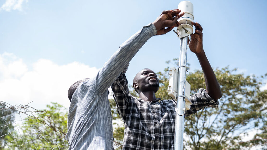
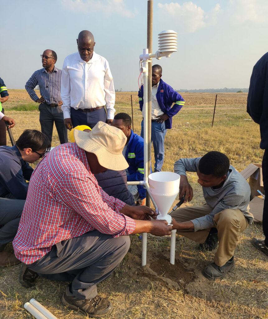
Selker and his colleague at the Delft University of Technology, Nick van de Giesen, brainstormed a solution: a low-cost weather station that could transmit meteorological and hydrological data over cell networks. They called their new project the Trans-African Hydro-Meteorological Observatory, or TAHMO.
With TAHMO, “the question was, What can we do now to improve on the density of stations to ensure that we can have reliable data from Africa that can both help feed the global models and [create] local models that are as accurate and useful as the ones that we have in the U.S. and EU countries?” said Annor, TAHMO’s CEO.
To date, TAHMO has worked with national liaison agencies (most frequently, national meteorological agencies) to install more than 750 stations in 23 countries and has collected more than 7 billion total observations. The stations, owned and installed by TAHMO, measure standard weather parameters such as precipitation, wind speed, wind direction, relative humidity, temperature, and solar radiation. Often, TAHMO approaches national meteorological agencies with a proposal to install stations, though some countries have asked TAHMO for assistance, too.
The data from TAHMO stations are shared directly with each country’s liaison agency. Each agreement between TAHMO and a country allows TAHMO to make these data available for any researchers interested in using them in peer-reviewed studies. It also gives a country the right to halt data collection, if it chooses.
“Policymakers are supposed to be guided by climate scientists, and the climate scientists can only authoritatively talk about that if they have quality data.”
Mburu, the longtime Kenyan meteorologist, became one of TAHMO’s main contacts in that country, helping to establish a relationship between the organization and the Kenya Meteorological Department. Now semiretired, he is a consultant for TAHMO at the organization’s headquarters, located in Nairobi. In Kenya, he said, TAHMO stations have been the most reliable forecasting system over the past decade.
Data from TAHMO stations have given Kenya’s Meteorological Department significant insight into what causes flooding, especially in Nairobi County, said Paul Murage, a climate scientist at the department who also trains other meteorologists at the WMO regional training center in Nairobi. Flash flooding has become a significant issue in the city; Murage recounted a day in March 2024 when the Nairobi Expressway, a major roadway, was impassable during heavy rains.
Murage said having rainfall data from TAHMO stations empowers his agency to persuade policymakers that better, climate-proofed infrastructure is needed. “Policymakers are supposed to be guided by climate scientists, and the climate scientists can only authoritatively talk about that if they have quality data,” he said.
TAHMO stations were included in the High Impact Weather Lake System Project (HIGHWAY), the WMO project to improve early-warning systems across Lake Victoria.
Another U.S.-based project, called 3D-PAWS (for 3D-Printed Automatic Weather Station), works with national meteorological agencies in developing countries to establish 3D printing fabrication facilities, install 3D printed, low-cost observational stations, and train local staff to maintain their own stations long term.
The group has worked with six African countries—Kenya, Malawi, Senegal, Uganda, Zambia, and Zimbabwe—and has deployed more than 250 stations. Prior to being dissolved in July 2025, the U.S. Agency for International Development (USAID) was a major 3D-PAWS funder, connecting the organization with countries via requests from national meteorological agencies in Africa.
The goal is for each country to eventually run its network completely on its own, said Paul Kucera, an atmospheric scientist at the University Corporation for Atmospheric Research (UCAR) who codeveloped the 3D-PAWS program with his colleague Martin Steinson. They designed the original 3D printed stations themselves and incorporated feedback from international partners in newer iterations of the design.
Each partner country owns the stations once they’re installed. Though the initial training and installations are supported by grants to 3D-PAWS, the expectation is that each country’s own staff will incorporate the costs of operation and maintenance into its annual budgets after a few years.
Barbados, one of the countries outside Africa that 3D-PAWS works with, now has a self-sufficient team independent of the 3D-PAWS group that provides feedback to 3D-PAWS on how to improve their operations. Kucera hopes Kenya will be the first African country to achieve the same level of independence.
The 3D-PAWS data are typically open to the public via a free database system. Near-real-time data from 3D-PAWS stations in Kenya and Zimbabwe are also sent to the Famine Early Warning Systems Network (FEWS NET), a program established by USAID to provide early-warning systems for famine. Kucera’s own research group aims to use the data to develop other tools, such as automatic early alerts for weather events.
Many national governments in Africa are investing in climate services, too, Shilenje said. He’s seen an increase in the number of countries adopting national frameworks for climate services and putting plans in motion to improve weather networks.
As one example, the Tanzania Meteorological Authority installed five new weather radars in 2024, bringing the countrywide total to seven and giving Tanzania the greatest number of radars in East and Central Africa. It’s “quite a significant investment” for a single African country to make, Shilenje said.
Global Support
Larger, international efforts also provide assistance. In 2021, the WMO launched the Systematic Observations Financing Facility (SOFF), a partnership between the WMO, United Nations Environment Programme, United Nations Development Programme, and United Nations Multi-Partner Trust Fund meant to finance advancements in weather observational networks in developing countries through grants. SOFF is also part of the U.N. Early Warnings for All initiative, a project aiming to ensure that everyone on Earth is protected from natural disasters by early-warning systems by 2027.
SOFF, now 3 years old, has partnered with 24 African countries to support station building, radiosonde launches, and continued maintenance of these networks. SOFF, like TAHMO and 3D-PAWS, emphasizes continued support after the initial installation of stations. SOFF does this via a peer-to-peer network of national meteorological agencies. Twenty-eight agencies worldwide have expressed interest in acting as peer mentors, many to African agencies, said Mario Peiró Espí from the partnership office at SOFF.
The concept has seen successes. Peiró Espí recounted a recent interaction with a staff member at the Austrian meteorological agency: “He said the guys in South Sudan write to him all the time to check on questions that before, they didn’t have anyone to check in with. They didn’t have any number to call and say, ‘Hey, we are facing this challenge, we don’t know how to solve it, can you help us?’”
Nine of SOFF’s African partner countries have entered the organization’s investment phase, during which national meteorological agency staff install stations and launch radiosondes with SOFF support. Mozambique, a coastal nation that frequently faces destructive floods and tropical cyclones, is one of those countries.
During a flooding event in 2000, Mozambique lost the majority of its weather stations. A $7.8 million grant from SOFF is helping the country’s national meteorological agency to recover the network by establishing 6 new land-based weather stations, upgrading 15 existing stations, and launching 4 airborne stations.
Farther north, Chad faces a dire lack of weather data, too—as of October 2024, Chad was reporting just 3% of the surface weather observations required by the GBON agreement. SOFF is working with the country toward the goal of installing or upgrading at least 34 weather stations.
Markus Repnik, SOFF’s director, feels strongly that the world should think of improvements in Africa’s observational networks not just as assistance to Africa but as a global public good. The world is dependent on African meteorological agencies for accurate forecasts everywhere, he said. It’s as much as 20 times more valuable to install a single station in a data-poor area of Africa than to add one to a European network, he said.
While 3D-PAWS, TAHMO, and SOFF focus on station building and radiosonde launching, other groups lend additional support. Beyond investments in SOFF, the WMO is spending roughly $56 million in Africa on climate service projects such as those used to support improved food security and health outcomes.
Dinku’s research group has an additional solution: the so-called ENACTS (Enhancing National Climate Services) approach.
Via ENACTS, Dinku and his colleagues work with countries’ national meteorological and hydrological services to create more comprehensive and usable precipitation and temperature datasets. For rainfall, they combine a country’s meteorological station data with satellite rainfall estimates to improve the coverage of the dataset. For temperature, they use reanalysis to fill in missing past data points.
ENACTS prioritizes satellite and modeling work over installing new stations because new stations can’t provide the decades of past data needed to provide reliable forecasts or understand climate trends now. ENACTS has been implemented in 15 African countries at the national level.
An Upward, Uncertain Trend
Thanks to these efforts and others, the number and density of reporting weather stations in Africa continue to tick slowly upward. Philanthropic donors are beginning to understand the importance of a robust, global weather observation system, and the need for improvements has gotten recent exposure on the world stage. But there’s still a long way to go before observational networks on the continent reach the density of those in Europe or North America.
One ever-present barrier is funding. Many African countries still lack the financial resources to improve their meteorological services, according to a recent WMO report. Even SOFF, which has been able to mobilize more than $100 million in grants in the 4 years it’s existed, faces a “very challenging fundraising environment,” Peiró Espí said. SOFF needs an additional $200 million by the end of 2026 to meet the needs of the countries it’s working with.
Facing such fundraising challenges, SOFF plans to announce a new funding mechanism, the SOFF Impact Bond, at COP30 (the 30th Conference of the Parties) in Belém, Brazil. The bond will “make resources available upfront…while allowing donors to spread contributions over a longer period,” according to SOFF.
A changing political landscape in the United States could pose obstacles, too. This summer, the Trump administration officially shut down USAID and said many of its programs would be absorbed by the U.S. State Department. Kucera said 3D-PAWS is still waiting to hear whether the changes will affect its fiscal year 2026 funding, but the group is being “cautiously optimistic” and working to diversify its funding sources.
Fragmentation of efforts also slows progress. Africa is full of fragmented investments, Repnik said. “In each and every country, you have a hodgepodge of investments.”
“The future benefits [of more investment] will be immense.”
This hodgepodge leads to scenarios like the one that Dinku witnessed in Kenya, where the national meteorological agency receives data from a handful of different types of weather stations provided by various nongovernmental organizations and intergovernmental organizations, all with different data reporting systems. Shilenje’s seen this too: “You have different companies providing different sets of equipment,” he said. “It may be working very well, but compatibility is a challenge.”
To help with that issue, Dinku and a colleague created a data tool that allows users to access, process, perform quality control on, and visualize data from all their different weather station systems.
The WMO is working to solve the fragmentation issue as well, including efforts to improve national meteorological agencies’ digital capacity, a software tool to homogenize data, and the African Partner Coordination Mechanism, a platform by which nongovernmental organizations, intergovernmental organizations, and companies can exchange plans and objectives to ensure that everybody is working toward the same goal.
Still, collaboration and coordination are an uphill battle, Dinku said. “The last two or three decades, we have been talking about coordination. But everybody talks about coordination, and then they go about doing their own thing.”
Climate change only adds urgency to the efforts. As the climate warms, it will become even more variable. Risky decisions that farmers make about when, where, and what to plant will come with higher consequences than they once did. Mitigating the effects of climate change “will not happen without proper climate services,” Mburu said, adding that a robust observational network is critical to drastically reduce the impacts of climate change in Africa.
“The future benefits [of more investment] will be immense,” he said.
—Grace van Deelen (@gvd.bsky.social), Staff Writer
Citation: van Deelen, G. (2025), Building better weather networks, Eos, 106, https://doi.org/10.1029/2025EO250386. Published on 27 October 2025.
Text © 2025. AGU. CC BY-NC-ND 3.0
Except where otherwise noted, images are subject to copyright. Any reuse without express permission from the copyright owner is prohibited.